

3. Project Planning And Management
The degree of project planning required for a water storage project can vary widely depending on if the project is a Government project, an NGO project, a community sponsored project or a private project. There are, however many common items that should be considered.
3.1 Project Cycle Approach
A project cycle approach that encompasses the following should be adopted.
- Needs Assessment,
- Specific Planning,
- Implementation,
- Evaluation and Monitoring.
Stakeholder engagement and needs assessment are discussed in Chapter 5. Other general planning and implementation related topics are discussed below.
3.2 Definition of Objectives
The development of small dams, pans and other water conservation structures is an investment towards improving water access and security for one or multiple types of users e.g. domestic, livestock, agriculture, industry, recreation, tourism, flood control, hydro-power and environment. The different types of users may have different, and possibly competitive, interests in the water conservation structure. Defining the objectives is important for the design process as it will guide aspects of reliability, water quality, drawoff works, and the need for ancillary structures.
When planning the construction and/or rehabilitation of small water conservation structures, the following considerations regarding the various possible uses of the stored water should be taken into account:
3.2.1 Domestic Water Supply
Reservoir water, being an open water source is generally of poor quality with respect to drinking water standards and should not be used for domestic purposes without treatment. If the purpose of the structure is domestic water supply, then adequate attention should be given to:
- Minimising the likelihood of contamination from industrial, agricultural, livestock or human pollution (see Chapter 7 on Catchment Conservation);
- Minimising direct livestock, wildlife and human access to the reservoir;
- Providing water drawing facilities (e.g. water kiosk) so that domestic users can obtain the water without having to enter the reservoir area;
- Providing water treatment facilities. Where the capital and operation and maintenance requirements rule out the inclusion of a full water treatment facility measures to improve water quality as much as possible should be considered. In addition, domestic users should be guided on how to acquire and use household water treatment options (UNICEF, FAO and Oxfam GB, 2012). Simple methods for improving the quality of water from small dams and pans will be limited to reducing the turbidity of the water by use of horizontal gravel/sand filters (dams) or dug wells (pans). Prolonged light free storage may also be beneficial (Twort, Ratnayaka, & Brandt, 2000): it reduces turbidity by sedimentation and it reduces pathogenic bacteria as well. However, prolonged storage will usually lower the oxygen content of the water. For killing the schistosome larvae (bilharzia) a storage period of 48 hours is adequate (Cairncross & Fleachem, 1993).
By virtue of being an open water source, the provision of water from a dam or pan without treatment to meet domestic water requirements does not meet the government criteria of an improved supply and therefore does not improve access to water for that population. Consequently adequate consideration of alternative options to meet domestic water demand should be given which may provide an adequate quantity and quality of water for domestic purposes.
3.2.2 Livestock Supply
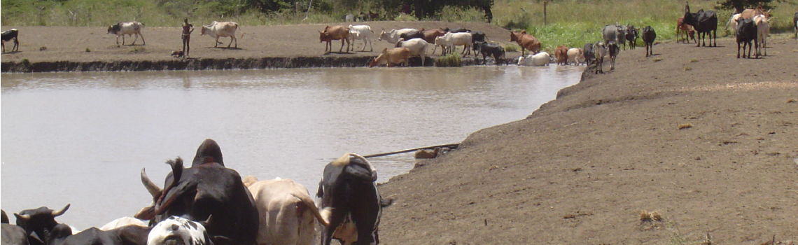
The use of water of lower quality than required for domestic water supply is permitted. In general, livestock water supply is the most common purpose of the construction and rehabilitation of small dams and pans in the ASALs. It should however be noted, that in order to avoid severe pollution of the reservoir water, straight watering of livestock from the reservoir should be discouraged. (This is in particular the case if the water from the reservoir is also to be used for domestic supply!) Therefore, draw-off facilities (e.g. cattle troughs) should, where possible, be provided.
The intimate relationship between water supply and rangeland for livestock implies that other issues other than water quality, are of paramount importance for livestock supply:
- Location of the site and the impact of additional livestock watering on the rangeland;
- The reliability of the water supply. One way to limit the risk of overgrazing in the vicinity of the dam/pan is to restrict the reliability of the water supply so that the structure is expected to dry out two to four months after the end of the rains.
3.2.3 Irrigation
The use of a dam/pan for irrigation requires careful consideration of the following points:
- Irrigation requires more water than domestic or livestock uses and so careful analysis of the water storage capacity and reliability is required to see what scale of irrigation can be sustained. Small dams and pans have been used successfully to support micro-irrigation activities for smallholder irrigation of high value crops, tree nurseries, establishing early planting material and “kitchen gardens” which provide significant livelihood, nutritional and food security benefits.
- Detailed analysis of the topography to determine whether the reservoir water can be used by gravity supply or whether a pumped supply system is required.
- Irrigation efficiency, in general, more water efficient irrigation techniques should be employed to maximize the productive use of the stored water.
- Type of soils, soils must be suitable for long term irrigated farming.
- Water quality is an issue if drip irrigation systems are to be employed.
3.2.4 Wildlife Supply
The same remarks as for livestock supply apply to wildlife. Prevention of wildlife from entering a dam or pan is very difficult and any prevention system should be species specific. In general, wildlife that is likely to damage the structure, pose a risk to other users, or materially affect the water quality, should be denied access. Provision of wildlife water away from the structure, possibly through a gravity draw off pipe, is one way to alleviate pressure on the structure itself but can only be used in combination with fencing the site. Both the fence and distribution works should be wildlife-proof.
The most notorious wildlife vandals for water structures are elephants. Stone wall, bees and electric fences are some of the options that have been tried and can be considered.
Wildlife supply is usually difficult to combine with domestic water supply. The nature and extent of possible wildlife interference should be investigated during the planning and design stages of the dam/pan and consultation with Kenya Wildlife Services or wildlife experts is advisable.
3.2.5 Fish Breeding
Fish breeding can be combined with most other purposes on condition that the water level and water quality throughout the year are sufficient to sustain the aquatic life
3.2.6 Water Conservation
While there may seem to be an inherent value in conserving runoff and flood waters, the expense and environmental risk does not justify a project in which the purpose is so ambiguous. Careful review of the purpose of the project should be undertaken.
3.2.7 Flood Control and Stream Flow Regulation
Flood control and stream flow regulation implies that the intended structure has sufficient storage capacity to attenuate peak flood flows and sufficient capacity to enable the controlled release of the flood water during low flow periods. For a dam to provide this function, the water level is likely to fluctuate rapidly over the year with releases structured to result in low water levels at the start of the rainy season.
In general dams established for this purpose are large and require specialised investigations and analysis and are beyond the scope of this manual.
3.2.8 Hydropower
The development of a dam for hydro-power purposes is a specialised topic which is beyond the scope of this manual. In general, the size and scope of the dams described in this manual are not large enough for hydro-power development.
3.3 Water Demand Analysis
3.3.1 Initial Estimate
The RELMA Manual “Water from ponds, dams and pans” (Lindqvist A.K, 2005) recommends the following initial calculations for small scale reservoirs
Table 3-1: RELMA Recommended Calculations for Small Scale Water Demand
| Item | Population | Consumption Rate (litres/day) | Total (litres/day) |
|---|---|---|---|
| People | x 20 | ||
| Camels | x 15 | ||
| Cattle | x 15 | ||
| Sheep/Goats | x 3.5 | ||
| Donkeys | x 15 | ||
| Irrigation | x 20 litre buckets/day | ||
| Other | +10% (seepage and evaporation losses) | ||
| Total (Litres/day) | |||
| Total (cubic meters/day) Divide total litre by 1,000) |
For a more detailed estimation of the water demand, reference should be made to the Practice Manual for Water Supply Services in Kenya – Part A (Ministry of Water and Irrigation, 2005). A brief summary of the key points from this manual is presented in the following section.
3.3.2 Design Period
The water demand should be estimated for the initial, future and ultimate periods to provide some anticipation of future demands. The initial period covers the current demand, the future period covers the demand after 10 years and the ultimate period covers the demand after 20 years. Storage structures should be designed to meet the ultimate demand where possible.
3.3.3 Supply Area
In order to establish the demand, the supply area must be defined. In an ASAL area where there are no other water sources, the following guidelines can be used:
- 5 km radius for domestic users
- 5 km radius for sheep and goats
- 10 km radius for cattle and wildlife
- 15 km radius for camels
Where other water sources exist, the demand can be attributed to the different sources based on proximity, water quality preferences or other relevant local conditions.
3.3.4 Domestic Water Demand
-
Population Projections
Population estimates should make use of the most current census data provided by the KNBS. The smallest unit for which data is provided is the sub-location. This information can be cross checked with current information from the local administration.
The population to be served is based on the sub-location population data. The proportion of the supply area falling in each sub-location should therefore be established. Superimposing a map of the supply area boundaries over a map of the administrative boundaries will provide the supply area within each sub-location. This can be done easily using GIS software.
The initial population within each sub-location is established using local key informants (e.g. local administration), field surveys or is based on the supply area within each sub-location using Equation 3-1.
Equation 3-1
$\mathbf{P_i = {P_T \over A_T} \; \times \; A_i}$
Where
$P_i \; = \;$ Population of sub-location “i” in the supply area
$P_T \; = \;$ Total population in sub-location “i”
$A_T \; = \;$ Total area of sub-location “i” [ $\; km^2 $ ]
$A_i \; = \;$ Supply area within sub-location “i” as established by GIS(e.g. ARCGIS, MAPINFO), manually from a map or through Google Earth in $\; km^2 $
Future population estimates can established based on Equation 3-2.
Equation 3-2
$\mathbf{P_{yn} = P_{y0}(1 \; + \; {r \over 100})^n }$
Where
$n \; = \;$ number of years projecting forward from year 0.
$P_{yn} \; = \;$ Population in year n
$P_{y0} \; = \;$ Population in year 0 i.e. year of census or year data collected.
$r \; = \;$ projected annual population growth rate[%] as defined by KNBS or other reliable sources. Population growth in 2014 was approximately 2.7%.
It should also be kept in mind that especially in the ASALs rapid population increases can occur, due not only to a high natural population growth rate, but also through migration from densely populated higher potential areas. Population projections should try to take this phenomenon into account. It should be noted that any significant improvement in the water supply in a certain area might actually induce further migration of people and livestock towards that area. Allowing for this is best done by using an adjusted population growth rate that allows for an influx of people and livestock. Determining a reasonable adjustment is a very subjective task that should be clearly identified and described in any preliminary calculations.
-
Service Level
The service level has a direct bearing on the consumption rate as those with individual connections (IC) will generally consume more that those without (NC). In order to estimate water demand, an estimate should be made of the proportion of the population that will be supplied through individual connections. Table 3-2 and Table 3-3 provide classes and values that can be used. However, where no distribution system is designed or anticipated, then the population can be expected to remain with no individual connections. For the purposes of this table, the following descriptions can be used.
Table 3-2: High, Low and Medium Potential/Class Brackets
Category Description Urban High Class Low density housing on 0.2 ha or larger plots, houses with internal hot water systems Urban Medium Class Low density housing on 0.1 ha or smaller plots. Houses with internal cold water Urban Low Class High density housing, houses with internal cold water but many external facilities Rural High Potential Areas with rainfall over 1,000mm/year Rural Medium Potential Areas with rainfall 500mm to 1,000mm/year Rural Low Potential Areas with rainfall less than 500mm/year Table 3-3: Proportion of Population Service with Different Service Level
Proportion of Population with Individual Connections (IC) [%] Proportion of Population without Individual Connections(NC) [%] Initial Future Ultimate Inital Future Ultimate Urban Areas High & medium Class housing 100 100 100 0 0 0 Low class housing 10 30 50 90 70 50 Rural Areas High Potential 20 40 80 80 60 20 Medium Potential 10 20 40 90 80 60 Low Potential 5 10 20 95 90 80 (Source: MWI Practice Manual for Water Supply Services, 2005)
3.3.5 Livestock Water Demand
-
Livestock Population
The present livestock population should be based on government records which include:
- Livestock census data;
- Water Master Plans (Country or National).
Where no government records are available, the livestock population can be estimated based on the annual rainfall as indicated in Table 3-4
Table 3-4: Livestock units per hectare
Annual Rainfall (mm) Livestock Units per ha Less than 400 0.4 400 - 600 0.6 600 - 800 0.8 800 - 1000 1.0 1000 - 1200 1.3 1200 - 1700 1.7 Over 1700 2.5 (Source: MoWI Practice Manual for Water Supply Services, 2005)
-
Future Livestock Populations
Unless there is reliable information that the livestock data represented a period of unusually high or low livestock numbers, future livestock populations are expected to remain fairly constant and are hard to predict as the numbers may vary with rainfall, disease, security and other external factors.
-
Livestock Units
A convenient unit of measurement for livestock is known as the Livestock Unit (LSU). According to the National Water Master Plan 2030 one LSU consumes 50l/head/day of water. Conversion of stock numbers to livestock units is achieved using Table 3-5.
Table 3-5: Conversion of Stock to Livestock Units
Stock Type Equivalent LSU 1 Grade Cow 1 LSU 3 Indigenous cows 1 LSU 15 Sheep or goats 1 LSU 5 Donkeys 1 LSU 2 Camels 1 LSU 3 Pigs 1 LSU 50 Rabbits 1 LSU 165 Poultry 1 LSU The NWMP, 2013 considers livestock water demand for pigs and poultry as negligible and does not include figures for them (JICA; Nippon Koei Co.Ltd., 2013). The figures for pigs, rabbits and poultry above have been estimated based on experience.
3.3.6 Wildlife Water Demand
In general, wildlife water demand can be extremely difficult to estimate due to the movements of wildlife populations. Water storage for wildlife use can use figures based on the following table. The NWMP, 2013 classifies wildlife water consumption rates into two groups, depending on their water requirements as shown below:
- Group A:
Elephant, zebra, wildebeest, kudu, warthog and buffalo (these species require relatively much water
- Group B:
Giraffe, gazelle, gerenuk, impala, hartebeest, topi, eland, oryx and ostrich (these species require relatively less water)
The respective unit water consumption rates are given in Table 3-6 below:
Table 3-6: Unit Water Consumption Rate of Wildlife
| Group | Unit Water Consumption | Remarks |
|---|---|---|
| Group A | 5 l/100kg/day | About 50% of standard water consumption of one livestock unit |
| Group B | 2.5 l/100kg/day | About 25% of standard water consumption of one livestock unit |
(Source: NWMP, 2030)
Alternatively, Table 3-7 below is based on local experience and gives estimated wildlife water use figures for a variety of wildlife.
Table 3-7: Wildlife Water Use Figures
| Species | Body weight, kilogrammes | Demand, litres per day (litres per animal per day) |
|---|---|---|
| Wildebeest | 200 | 9 |
| Zebra | 400 | 18 |
| Buffalo | 800 | 36 |
| Elephant | 4000 | 182 |
| Eland | 600 | 27 |
| Lion& other predators | varies | 10 (but varies) |
| Waterbuck | 200 | 9 |
| Bushbuck | 50 | 2 |
| Reedbuck | 80 | 5 |
| Impala | 80 | 4 |
| Grants Gazelle | 60 | 3 |
| Thomson’s Gazelle | 20 | 1 |
| Warthog | 80 | 4 |
| Rhino | 1000 | 45 |
| Giraffe | 750 | 36 |
| Baboon | 15 | 7 |
| Ostrich | 80 | 4 |
| Kongoni | 110 | 5 |
| Hippopotamus | 2500 | 114 |
3.3.7 Institutional Water Demand
-
Schools
Unless specific information is gathered from government records or field surveys, it may be assumed that 30% of the population attend primary and/or secondary school. The County Integrated Development Plan or more localised development plans may have relevant updated details.
-
Health Centres
Unless specific information is gathered from government records or field surveys, it may be assumed that one health centre and two to four dispensaries will serve about 35-40,000 people with one hospital bed per 1250 people.
3.3.8 Water Consumption Rates
Consumption rates are presented in Table 3-8. A provision of 20% allowance for water losses from leakage and wastage should be factored in.
Table 3-8: Consumption Rates
| CONSUMER | UNIT | RURAL AREAS | URBAN AREAS | ||||
|---|---|---|---|---|---|---|---|
| High potential | Medium potential | Low potential | High Class Housing | Medium Class Housing | Low Class Housing | ||
| People with individual connections | 1/head/day | 60 | 50 | 40 | 250 | 150 | 75 |
| People without connections | 1/head/day | 20 | 15 | 10 | - | - | 20 |
| Livestock unit | 1/LSU/day | 50 | |||||
| Boarding schools | 1/head/day | 50 | |||||
| Day schools
With WC Without WC |
1/head/day |
25 5 |
|||||
| Hospitals
Regional District Other |
1/bed/day |
400 + 20 1 per outpatient and day (minimum 5000 1/day) 200 + 20 1 per outpatient and day (minimum 5000 1/day) 100 + 20 1 per outpatient and day (minimum 5000 1/day) |
|||||
| Deispensary and Health Centre | 1/day | 5000 | |||||
| Hotels
High Class Medium Class Low Class |
1/bed/day |
600 300 50 |
|||||
| Administrative offices | 1/head/day | 25 | |||||
| Bars | 1/day | 500 | |||||
| Shops | 1/day | 100 | |||||
| Unspecified industry | 1/ha/day | 20,000 | |||||
| Coffee pulping factories | 1 Kg coffee | 25(when re-circulation of water is used) | |||||
(Source: MWI Practice Manual for Water Supply Services, 2005)
3.3.9 Irrigation Water Demand
The reader is referred to the Practice Manual for Water Supply Services in Kenya – Part B (Ministry of Water and Irrigation, 2005) for a detailed methodology to establish the irrigation water demand.
The values presented in Table 3-9 are based on experience and can be used as a rough guide for planning purposes.
Table 3-9: Irrigation Water Use
| Type of Irrigation | Irrigation Water Requirement
[m^3/ha/day] |
|---|---|
| Drip | 60 |
| Overhead sprinkler | 90 |
| Surface | 120 |
These values broadly reflect the peak irrigation supply requirements and include conveyance and field application efficiencies. The values do not consider effective rainfall and so should not be used to establish annual water supply requirements. These values are useful for establishing how many days of irrigation supply can be provided by the reservoir. For example, the 90 day storage requirement (typically required by WRMA to support a water permit for irrigation purposes) responds to the need for an irrigator to be able to meet his/her irrigation demands for the entire duration of the dry season (roughly three months or 90 days).
3.3.10 Evaporation Losses
At the planning stage of the project an estimate is required of the likely loss from evaporation from the water surface. Monthly open water evaporation estimates for average and dry (1 in 5) conditions are provided in Table 3-10 and Table 3-11 based on Studies of Potential Evaporation in Kenya (Woodhead, 1968).
Evaporation pan data are a fair estimate of open water evaporation and can be obtained from the government institutions such as KMS, KARI and WRMA.
Maximum daily evaporation loss can be estimated using Equation 3-3.
Equation 3-3
$\mathbf{E_{vol} = A_{max} \; \times \; E_o \; \times \; 10}$
Where
$E_{vol} \; = \;$ Maximum evaporative losses [$m^3$ / day ]
$A_{max} \; = \;$ Maximum reservoir surface area [ha]
$E_{o} \; = \;$ Open water evaporation [mm / day] as defined by the average over the dry season months
Table 3-10: Average Monthly Open Water Evaporation [mm]
| Station | Altitude | Jan | Feb | Mar | Apr | May | Jun | Jul | Aug | Sep | Oct | Nov | Dec | Total | |
|---|---|---|---|---|---|---|---|---|---|---|---|---|---|---|---|
| 1 | Ahero | 1200 | 205 | 195 | 212 | 179 | 178 | 169 | 167 | 175 | 194 | 200 | 180 | 182 | 2236 |
| 2 | Ainabkoi | 2600 | 165 | 162 | 174 | 126 | 126 | 98 | 110 | 85 | 142 | 150 | 116 | 136 | 1590 |
| 3 | Archers Post | 865 | 210 | 210 | 230 | 208 | 215 | 210 | 215 | 230 | 240 | 230 | 182 | 185 | 2565 |
| 4 | Bachuma | 400 | 200 | 185 | 198 | 182 | 160 | 158 | 156 | 162 | 177 | 190 | 182 | 189 | 2139 |
| 5 | Baricho | 70 | 195 | 195 | 215 | 185 | 165 | 165 | 165 | 180 | 185 | 195 | 190 | 195 | 2230 |
| 6 | Busia | 1180 | 182 | 170 | 184 | 170 | 170 | 158 | 152 | 164 | 183 | 186 | 164 | 173 | 2056 |
| 7 | Chebloch | 1200 | 185 | 176 | 191 | 169 | 171 | 156 | 151 | 164 | 174 | 179 | 164 | 170 | 2050 |
| 8 | Eldoret | 2100 | 182 | 177 | 195 | 160 | 148 | 126 | 118 | 123 | 148 | 170 | 168 | 168 | 1883 |
| 9 | Equator | 2760 | 179 | 177 | 192 | 151 | 140 | 117 | 104 | 111 | 139 | 161 | 153 | 164 | 1788 |
| 10 | Garissa | 130 | 201 | 191 | 216 | 203 | 207 | 183 | 188 | 199 | 206 | 219 | 182 | 179 | 2374 |
| 11 | Gede | 30 | 189 | 165 | 191 | 178 | 155 | 137 | 148 | 155 | 176 | 192 | 181 | 185 | 2052 |
| 12 | Habaswein | 200 | 246 | 257 | 277 | 248 | 275 | 273 | 272 | 282 | 291 | 286 | 205 | 208 | 3120 |
| 13 | Hola | 90 | 198 | 202 | 221 | 191 | 191 | 168 | 169 | 182 | 191 | 198 | 190 | 192 | 2293 |
| 14 | Isiolo | 1100 | 209 | 208 | 230 | 206 | 216 | 209 | 215 | 231 | 241 | 228 | 181 | 187 | 2561 |
| 15 | Kabondori | 1140 | 180 | 165 | 164 | 146 | 125 | 98 | 120 | 119 | 163 | 157 | 129 | 138 | 1704 |
| 16 | Kapenguria | 2130 | 145 | 153 | 157 | 131 | 131 | 124 | 101 | 117 | 133 | 131 | 123 | 142 | 1588 |
| 17 | Kapsabet | 2000 | 177 | 176 | 198 | 162 | 152 | 136 | 138 | 148 | 166 | 176 | 171 | 169 | 1969 |
| 18 | Kaputir | 700 | 205 | 200 | 200 | 175 | 180 | 165 | 165 | 175 | 195 | 200 | 185 | 190 | 2235 |
| 19 | Katumani | 1600 | 181 | 165 | 166 | 136 | 145 | 126 | 116 | 125 | 153 | 171 | 136 | 170 | 1790 |
| 20 | Kedong | 1900 | 176 | 161 | 176 | 147 | 129 | 117 | 111 | 124 | 147 | 171 | 150 | 152 | 1761 |
| 21 | Kericho | 2070 | 160 | 152 | 166 | 125 | 130 | 125 | 121 | 120 | 124 | 125 | 121 | 141 | 1610 |
| 22 | Kiambu | 1730 | 192 | 178 | 180 | 138 | 129 | 98 | 109 | 117 | 158 | 166 | 151 | 165 | 1781 |
| 23 | Kibos | 1170 | 203 | 197 | 217 | 191 | 188 | 174 | 174 | 187 | 202 | 217 | 192 | 198 | 2340 |
| 24 | Kimakia | 2500 | 150 | 149 | 160 | 132 | 116 | 105 | 89 | 99 | 122 | 143 | 131 | 132 | 1528 |
| 25 | Kipkabus | 2400 | 178 | 183 | 199 | 152 | 149 | 116 | 124 | 128 | 156 | 177 | 152 | 165 | 1879 |
| 26 | Kisumu | 1140 | 187 | 182 | 195 | 164 | 157 | 143 | 144 | 156 | 165 | 182 | 167 | 176 | 2018 |
| 27 | Kitale | 1900 | 180 | 170 | 192 | 167 | 151 | 139 | 131 | 147 | 161 | 169 | 155 | 163 | 1925 |
| 28 | Kitui | 1180 | 189 | 191 | 200 | 169 | 168 | 152 | 149 | 162 | 183 | 203 | 163 | 167 | 2096 |
| 29 | Koru | 1600 | 182 | 174 | 180 | 152 | 148 | 144 | 140 | 145 | 163 | 163 | 158 | 170 | 1919 |
| 30 | Lamu | 9 | 219 | 199 | 220 | 182 | 173 | 162 | 166 | 188 | 193 | 214 | 206 | 205 | 2327 |
| 31 | Lamuria | 1850 | 132 | 133 | 144 | 136 | 156 | 140 | 146 | 138 | 165 | 147 | 115 | 115 | 1667 |
| 32 | Lodwar | 500 | 227 | 210 | 232 | 204 | 235 | 221 | 221 | 226 | 239 | 255 | 220 | 224 | 2714 |
| 33 | Likichokio | 1050 | 200 | 200 | 200 | 175 | 200 | 175 | 175 | 175 | 200 | 210 | 190 | 197 | 2297 |
| 34 | Likitaung | 700 | 255 | 255 | 270 | 221 | 232 | 235 | 234 | 242 | 261 | 257 | 238 | 239 | 2939 |
| 35 | Machakos | 1650 | 190 | 174 | 182 | 151 | 140 | 129 | 128 | 140 | 169 | 180 | 158 | 166 | 1907 |
| 36 | Magadi | 613 | 230 | 227 | 246 | 201 | 194 | 185 | 196 | 204 | 223 | 238 | 218 | 223 | 2585 |
| 37 | Makindu | 1000 | 175 | 179 | 182 | 160 | 151 | 139 | 139 | 153 | 179 | 191 | 154 | 149 | 1951 |
| 38 | Malindi | 20 | 210 | 197 | 215 | 186 | 171 | 156 | 156 | 175 | 191 | 202 | 195 | 205 | 2259 |
| 39 | Mandera | 330 | 233 | 234 | 257 | 210 | 213 | 222 | 223 | 234 | 238 | 205 | 193 | 215 | 2677 |
| 40 | Maralal | 1950 | 161 | 159 | 173 | 151 | 151 | 132 | 130 | 132 | 151 | 157 | 139 | 150 | 1786 |
| 41 | Marigat | 1070 | 205 | 195 | 212 | 187 | 190 | 173 | 167 | 182 | 193 | 199 | 182 | 189 | 2274 |
| 42 | Marsabit | 1360 | 176 | 168 | 175 | 138 | 155 | 153 | 154 | 162 | 173 | 168 | 134 | 147 | 1903 |
| 43 | Masara | 1200 | 193 | 184 | 191 | 163 | 171 | 157 | 165 | 179 | 196 | 200 | 172 | 185 | 2156 |
| 44 | Meru | 1565 | 155 | 155 | 170 | 140 | 150 | 130 | 130 | 150 | 155 | 165 | 135 | 130 | 1765 |
| 45 | Molo | 2500 | 149 | 147 | 159 | 133 | 127 | 110 | 108 | 110 | 127 | 140 | 123 | 137 | 1570 |
| 46 | Mombasa | 60 | 211 | 204 | 221 | 180 | 152 | 148 | 144 | 162 | 181 | 198 | 200 | 204 | 2205 |
| 47 | Moyale | 1110 | 220 | 207 | 218 | 160 | 150 | 147 | 144 | 161 | 175 | 165 | 164 | 184 | 2095 |
| 48 | Muguga | 2100 | 173 | 171 | 186 | 141 | 116 | 107 | 96 | 109 | 143 | 171 | 149 | 152 | 1714 |
| 49 | MweaTebere | 1160 | 197 | 192 | 200 | 173 | 166 | 140 | 123 | 148 | 176 | 196 | 183 | 188 | 2082 |
| 50 | Mwingi | 1050 | 185 | 185 | 190 | 170 | 167 | 143 | 137 | 164 | 180 | 190 | 163 | 163 | 2037 |
| 51 | Nairobi Kab. | 1737 | 173 | 176 | 183 | 146 | 125 | 113 | 108 | 116 | 140 | 158 | 141 | 159 | 1738 |
| 52 | Nairobi Sth | 1675 | 195 | 189 | 192 | 157 | 144 | 122 | 119 | 132 | 166 | 184 | 169 | 179 | 1948 |
| 53 | Naivasha | 1900 | 167 | 160 | 169 | 134 | 137 | 123 | 126 | 133 | 153 | 160 | 139 | 153 | 1754 |
| 54 | Nakuru | 1890 | 137 | 156 | 163 | 133 | 139 | 132 | 138 | 141 | 145 | 142 | 121 | 146 | 1693 |
| 55 | Nanyuki | 1950 | 156 | 155 | 158 | 128 | 129 | 125 | 125 | 138 | 150 | 146 | 118 | 135 | 1663 |
| 56 | Narok | 1900 | 149 | 148 | 156 | 127 | 122 | 113 | 112 | 122 | 143 | 157 | 142 | 147 | 1638 |
| 57 | Ngao | 15 | 205 | 193 | 220 | 190 | 178 | 165 | 165 | 180 | 191 | 205 | 190 | 200 | 2282 |
| 58 | Nyeri | 1800 | 182 | 171 | 179 | 153 | 138 | 118 | 94 | 120 | 148 | 164 | 133 | 145 | 1745 |
| 59 | OlJoroOrok | 2380 | 129 | 131 | 152 | 117 | 122 | 109 | 94 | 101 | 117 | 122 | 110 | 108 | 1412 |
| 60 | Oloitokitok | 1850 | 160 | 123 | 116 | 124 | 117 | 107 | 91 | 104 | 128 | 170 | 150 | 148 | 1538 |
| 61 | P. Victoria | 1200 | 180 | 170 | 184 | 170 | 150 | 145 | 150 | 150 | 175 | 180 | 164 | 173 | 1991 |
| 62 | Ruiru | 1610 | 160 | 151 | 171 | 125 | 115 | 104 | 105 | 107 | 136 | 181 | 150 | 116 | 1621 |
| 63 | Rumuruti | 1860 | 181 | 177 | 196 | 171 | 168 | 149 | 150 | 158 | 178 | 186 | 167 | 178 | 2059 |
| 64 | Sigor | 1050 | 145 | 155 | 170 | 130 | 145 | 135 | 110 | 120 | 125 | 125 | 135 | 165 | 1660 |
| 65 | Sth Kinangop | 2600 | 116 | 113 | 129 | 110 | 99 | 88 | 81 | 86 | 100 | 119 | 105 | 105 | 1251 |
| 66 | Subukia | 2100 | 140 | 152 | 165 | 132 | 125 | 119 | 116 | 127 | 137 | 142 | 129 | 137 | 1621 |
| 67 | Taveta | 770 | 175 | 175 | 175 | 150 | 140 | 135 | 135 | 145 | 165 | 185 | 175 | 175 | 1930 |
| 68 | Thika | 1460 | 193 | 193 | 195 | 156 | 145 | 124 | 113 | 114 | 153 | 177 | 155 | 167 | 1885 |
| 69 | Voi | 560 | 183 | 187 | 198 | 176 | 166 | 158 | 156 | 162 | 174 | 189 | 182 | 175 | 2106 |
| 70 | Wajir | 240 | 233 | 225 | 238 | 205 | 205 | 199 | 201 | 206 | 213 | 207 | 187 | 208 | 2527 |
| 71 | Wayu | 160 | 203 | 190 | 209 | 190 | 190 | 167 | 173 | 187 | 191 | 193 | 182 | 198 | 2273 |
| 72 | Yatta | 1220 | 197 | 192 | 200 | 173 | 166 | 140 | 123 | 148 | 176 | 196 | 183 | 188 | 2082 |
* Note: Data from "Studies of Potential Evaporation in Kenya", T. Woodhead
Table 3-11: Monthly Open Water Evaporation for Dry Conditions (1 in 5) [mm]
| Station | Altitude | Jan | Feb | Mar | April | May | Jun | Jul | Aug | Sept | Oct | Nov | Dec | Total | |
|---|---|---|---|---|---|---|---|---|---|---|---|---|---|---|---|
| 1 | Ahero | 1200 | 238 | 218 | 235 | 202 | 201 | 188 | 197 | 198 | 223 | 227 | 212 | 216 | 2555 |
| 2 | Ainabkoi | 2600 | 186 | 178 | 189 | 139 | 139 | 107 | 126 | 94 | 156 | 166 | 133 | 156 | 1769 |
| 3 | Archers Post | 865 | 223 | 226 | 246 | 225 | 234 | 226 | 240 | 250 | 265 | 251 | 204 | 208 | 2798 |
| 4 | Bachuma | 400 | 223 | 201 | 214 | 199 | 175 | 171 | 175 | 177 | 197 | 209 | 205 | 215 | 2361 |
| 5 | Baricho | 70 | 218 | 211 | 232 | 201 | 181 | 178 | 186 | 197 | 205 | 214 | 214 | 221 | 2458 |
| 6 | Busia | 1180 | 209 | 190 | 200 | 187 | 188 | 172 | 176 | 181 | 206 | 208 | 187 | 199 | 2303 |
| 7 | Chebloch | 1200 | 202 | 187 | 202 | 180 | 184 | 166 | 165 | 176 | 188 | 194 | 181 | 188 | 2213 |
| 8 | Eldoret | 2100 | 205 | 193 | 212 | 176 | 164 | 138 | 134 | 136 | 166 | 189 | 192 | 194 | 2099 |
| 9 | Equator | 2760 | 202 | 193 | 208 | 167 | 155 | 128 | 119 | 122 | 156 | 179 | 175 | 189 | 1993 |
| 10 | Garissa | 130 | 224 | 207 | 233 | 222 | 226 | 198 | 211 | 218 | 228 | 241 | 205 | 203 | 2616 |
| 11 | Gede | 30 | 211 | 179 | 206 | 194 | 170 | 148 | 166 | 169 | 195 | 211 | 204 | 210 | 2263 |
| 12 | Habaswein | 200 | 275 | 279 | 298 | 271 | 301 | 295 | 306 | 308 | 322 | 315 | 231 | 236 | 3437 |
| 13 | Hola | 90 | 221 | 219 | 238 | 208 | 209 | 181 | 190 | 199 | 212 | 219 | 214 | 218 | 2528 |
| 14 | Isiolo | 1100 | 232 | 224 | 246 | 223 | 235 | 225 | 240 | 251 | 266 | 249 | 203 | 210 | 2804 |
| 15 | Kabondori | 1140 | 205 | 181 | 180 | 162 | 139 | 107 | 138 | 132 | 184 | 176 | 149 | 161 | 1914 |
| 16 | Kapenguria | 2130 | 167 | 170 | 173 | 147 | 147 | 137 | 117 | 132 | 152 | 147 | 144 | 167 | 1800 |
| 17 | Kapsabet | 2000 | 200 | 192 | 215 | 178 | 168 | 148 | 157 | 164 | 186 | 195 | 196 | 195 | 2194 |
| 18 | Kaputir | 700 | 224 | 212 | 211 | 187 | 193 | 175 | 181 | 187 | 211 | 216 | 204 | 210 | 2411 |
| 19 | Katumani | 1600 | 204 | 181 | 180 | 150 | 161 | 138 | 132 | 138 | 172 | 190 | 155 | 196 | 1997 |
| 20 | Kedong | 1900 | 204 | 180 | 195 | 166 | 145 | 130 | 130 | 140 | 168 | 194 | 176 | 180 | 2008 |
| 21 | Kericho | 2070 | 186 | 169 | 183 | 141 | 146 | 139 | 142 | 136 | 143 | 142 | 143 | 167 | 1837 |
| 22 | Kiambu | 1730 | 216 | 195 | 196 | 153 | 142 | 107 | 125 | 129 | 177 | 185 | 173 | 190 | 1988 |
| 23 | Kibos | 1170 | 232 | 217 | 238 | 213 | 210 | 192 | 201 | 209 | 229 | 244 | 222 | 232 | 2639 |
| 24 | Kimakia | 2500 | 171 | 165 | 176 | 147 | 129 | 115 | 102 | 111 | 138 | 161 | 152 | 156 | 1723 |
| 25 | Kipkabus | 2400 | 201 | 200 | 216 | 168 | 165 | 127 | 141 | 141 | 175 | 196 | 174 | 190 | 2094 |
| 26 | Kisumu | 1140 | 213 | 201 | 214 | 183 | 175 | 157 | 167 | 174 | 187 | 205 | 193 | 205 | 2274 |
| 27 | Kitale | 1900 | 207 | 189 | 211 | 187 | 169 | 154 | 152 | 165 | 184 | 191 | 181 | 192 | 2182 |
| 28 | Kitui | 1180 | 212 | 208 | 216 | 185 | 184 | 165 | 168 | 178 | 204 | 224 | 185 | 190 | 2319 |
| 29 | Koru | 1600 | 209 | 193 | 199 | 170 | 166 | 159 | 163 | 163 | 186 | 184 | 184 | 200 | 2176 |
| 30 | Lamu | 9 | 245 | 215 | 237 | 198 | 189 | 175 | 186 | 206 | 214 | 235 | 232 | 232 | 2564 |
| 31 | Lamuria | 1850 | 150 | 146 | 157 | 151 | 173 | 153 | 167 | 154 | 186 | 164 | 144 | 134 | 1879 |
| 32 | Lodwar | 500 | 253 | 227 | 250 | 223 | 257 | 239 | 247 | 247 | 265 | 281 | 248 | 254 | 2991 |
| 33 | Likichokio | 1050 | 223 | 217 | 215 | 191 | 219 | 189 | 196 | 191 | 222 | 230 | 214 | 224 | 2531 |
| 34 | Likitaung | 700 | 284 | 277 | 291 | 241 | 253 | 254 | 263 | 265 | 289 | 283 | 268 | 271 | 3239 |
| 35 | Machakos | 1650 | 214 | 190 | 198 | 167 | 155 | 141 | 146 | 155 | 190 | 200 | 181 | 191 | 2128 |
| 36 | Magadi | 613 | 260 | 248 | 267 | 221 | 214 | 202 | 223 | 226 | 250 | 265 | 250 | 257 | 2883 |
| 37 | Makindu | 1000 | 197 | 195 | 197 | 176 | 166 | 151 | 157 | 166 | 200 | 211 | 175 | 170 | 2161 |
| 38 | Malindi | 20 | 234 | 213 | 231 | 203 | 187 | 168 | 175 | 191 | 212 | 222 | 220 | 232 | 2488 |
| 39 | Mandera | 330 | 260 | 253 | 277 | 229 | 232 | 240 | 250 | 256 | 264 | 225 | 218 | 244 | 2948 |
| 40 | Maralal | 1950 | 178 | 171 | 185 | 163 | 164 | 142 | 145 | 144 | 167 | 172 | 155 | 169 | 1955 |
| 41 | Marigat | 1070 | 224 | 207 | 224 | 200 | 204 | 184 | 183 | 195 | 209 | 215 | 201 | 209 | 2455 |
| 42 | Marsabit | 1360 | 196 | 182 | 188 | 150 | 170 | 165 | 173 | 177 | 192 | 185 | 151 | 166 | 2095 |
| 43 | Masara | 1200 | 222 | 205 | 210 | 182 | 192 | 173 | 191 | 210 | 223 | 226 | 200 | 218 | 2452 |
| 44 | Meru | 1565 | 176 | 171 | 186 | 155 | 166 | 142 | 150 | 171 | 175 | 184 | 156 | 151 | 1983 |
| 45 | Molo | 2500 | 172 | 164 | 176 | 149 | 143 | 122 | 127 | 124 | 146 | 159 | 145 | 162 | 1789 |
| 46 | Mombasa | 60 | 235 | 220 | 238 | 196 | 164 | 160 | 162 | 177 | 200 | 217 | 226 | 231 | 2426 |
| 47 | Moyale | 1110 | 246 | 224 | 235 | 175 | 164 | 159 | 161 | 176 | 194 | 181 | 185 | 209 | 2309 |
| 48 | Muguga | 2100 | 203 | 193 | 208 | 160 | 132 | 120 | 114 | 125 | 166 | 197 | 179 | 182 | 1979 |
| 49 | MweaTebere | 1160 | 223 | 210 | 217 | 191 | 183 | 152 | 140 | 164 | 198 | 218 | 209 | 217 | 2322 |
| 50 | Mwingi | 1050 | 208 | 202 | 205 | 186 | 183 | 155 | 155 | 184 | 201 | 210 | 185 | 185 | 2259 |
| 51 | Nairobi Kab. | 1737 | 195 | 192 | 199 | 161 | 137 | 123 | 122 | 128 | 156 | 175 | 160 | 182 | 1930 |
| 52 | Nairobi Sth | 1675 | 220 | 207 | 208 | 173 | 160 | 133 | 136 | 145 | 186 | 205 | 193 | 206 | 2172 |
| 53 | Naivasha | 1900 | 191 | 177 | 185 | 150 | 153 | 135 | 145 | 149 | 174 | 179 | 162 | 179 | 1979 |
| 54 | Nakuru | 1890 | 156 | 172 | ` | 149 | 155 | 145 | 160 | 157 | 164 | 159 | 140 | 170 | 1727 |
| 55 | Nanyuki | 1950 | 177 | 171 | 173 | 142 | 143 | 137 | 144 | 154 | 169 | 163 | 136 | 157 | 1866 |
| 56 | Narok | 1900 | 172 | 164 | 172 | 142 | 137 | 125 | 130 | 137 | 163 | 177 | 165 | 173 | 1857 |
| 57 | Ngao | 15 | 219 | 206 | 237 | 207 | 194 | 178 | 186 | 197 | 212 | 225 | 214 | 228 | 2503 |
| 58 | Nyeri | 1800 | 207 | 188 | 195 | 169 | 154 | 130 | 108 | 133 | 167 | 183 | 153 | 168 | 1955 |
| 59 | OlJoroOrok | 2380 | 148 | 145 | 167 | 130 | 136 | 120 | 109 | 113 | 133 | 137 | 128 | 127 | 1593 |
| 60 | Oloitokitok | 1850 | 180 | 135 | 126 | 136 | 129 | 117 | 103 | 115 | 144 | 190 | 173 | 171 | 1719 |
| 61 | P. Victoria | 1200 | 203 | 186 | 200 | 187 | 166 | 160 | 172 | 166 | 196 | 201 | 187 | 199 | 2223 |
| 62 | Ruiru | 1610 | 182 | 167 | 187 | 138 | 127 | 114 | 121 | 119 | 153 | 202 | 173 | 135 | 1818 |
| 63 | Rumuruti | 1860 | 200 | 191 | 210 | 186 | 183 | 161 | 167 | 171 | 196 | 203 | 186 | 201 | 2255 |
| 64 | Sigor | 1050 | 167 | 172 | 187 | 146 | 163 | 149 | 127 | 135 | 143 | 140 | 158 | 194 | 1881 |
| 65 | Sth Kinangop | 2600 | 130 | 124 | 141 | 121 | 109 | 96 | 62 | 94 | 112 | 132 | 121 | 121 | 1363 |
| 66 | Subukia | 2100 | 160 | 168 | 181 | 147 | 140 | 131 | 134 | 142 | 155 | 159 | 150 | 160 | 1827 |
| 67 | Taveta | 770 | 195 | 190 | 189 | 164 | 153 | 146 | 151 | 158 | 183 | 204 | 197 | 198 | 2128 |
| 68 | Thika | 1460 | 219 | 212 | 213 | 173 | 161 | 136 | 129 | 126 | 172 | 198 | 179 | 193 | 2111 |
| 69 | Voi | 560 | 204 | 203 | 214 | 192 | 182 | 171 | 175 | 177 | 193 | 208 | 205 | 198 | 2322 |
| 70 | Wajir | 240 | 260 | 244 | 257 | 224 | 224 | 215 | 225 | 225 | 236 | 228 | 211 | 236 | 2785 |
| 71 | Wayu | 160 | 226 | 206 | 225 | 207 | 208 | 180 | 194 | 204 | 212 | 212 | 205 | 225 | 2504 |
| 72 | Yatta | 1220 | 223 | 210 | 217 | 191 | 183 | 152 | 140 | 164 | 198 | 218 | 209 | 217 | 2322 |
Source: Woodhead, T. 1968. Studies of Potential Evaporation in Kenya.East Africa Agriculture and Forestry Research Organization. Nairobi.
3.3.11 Seepage Losses
Seepage losses can occur through the floor of the reservoir area, and beneath or through the embankment. The seepage is a function of the hydraulic head, soil properties, the embankment design and construction techniques. At the planning stage of a project, a fair estimate of the seepage losses is needed. Table 3-12 provides hydraulic conductivity values for different soil conditions. Maximum daily seepage losses can be approximated using Equation 3-4 which assumes a unit hydraulic gradient and uses the surface area rather than the wetted surface area.
Table 3-12: Hydraulic Conductivity
| Water Depth(m) | Hydraulic Conductivity (m/s) | |
|---|---|---|
| Lower Limit | Upper Limit | |
| Permeable | ||
| Semi-permeable | ||
| Impermeable | ||
Equation 3-4
$\mathbf{S_{vol} = K \; \times \; A_{max} \; \times \; 86400}$
Where
$S_{vol} \; = \;$ Maximum evaporative losses [$m^3$/day ]
$K \; = \;$ Hydraulic Conductivity [m/s]
$A_{max} \; = \;$ Maximum reservoir surface area [ha]
3.3.12 Environmental Flows
Any requirement for downstream environmental flows should be factored into the water demand calculations. Environmental flows for perennial rivers and streams should be in line with the Q95 flows at the proposed dam site. Environmental flows for seasonal rivers are much harder to quantify and are generally not included in water demand calculations for storage on seasonal rivers.
3.4 Project Team
The planning, design, implementation and operation of a small dam, pan or water conservation structure requires a project team to bring together the expertise and skills required so that the project delivers sustainable benefits.
The roles and responsibilities for different project members are described below to facilitate teamwork and to help minimise disputes.
3.4.1 Project Proponent/Owner
The dam proponent or owner is any individual or body corporate who wishes to construct a water storage facility and who has legal access to the land on which the proposed structure is to be built.
The dam proponent must undertake the following:
- Submit a duly completed and signed Water Permit Application to WRMA, including form WRMA 001A and 001C;
- Pay the appropriate permit assessment fee which is dependant on the class of the permit application;
- Commission at his/her own cost a Dam Design Report carried out by a Qualified Water Resource Professional as set out in Section 57 of the WRM Rules (2007);
- Commission at his/her own cost an Environmental Impact Assessment (EIA) in accordance with the Environmental Management and Coordination Act 1999;
- Register the proposed project with the National Construction Authority within 30 days after awarding of the contract (NCA Regulations, 2014).
Once the WRMA has issued an Authorisation to Construct, the proponent must:
- Commission at his/her own cost a Qualified Contractor;
- Commission at his/her own cost a Qualified Water Resource Professional to supervise construction;
- Ensure that the construction is inspected at the milestones stated in the Authorisation to Construct;
- Ensure all risks (including third party) liability coverage for the duration of the construction work;
- Apply for an extension to the Authorisation to Construct in the event that the works are not completed within the allotted time.
Once the works are complete the proponent must submit a Completion Certificate (WRMA Form 008) to WRMA. This will provoke a final inspection by WRMA, and on satisfactory completion, WRMA will issue a Water Permit.
If an Emergency Action Plan (EAP) exists for the project, the proponent is responsible for ensuring that the EAP is adhered to. EAPs are discussed in detail in Section 3.6
An owner of an existing water conservation structure must:
- Ensure that the structure has a valid water permit. If the permit has expired then the dam owner must apply for a renewal;
- Ensure third party liability coverage to cover any injuries or damages that result from use of the structure or activities on the structure or failure of the structure;
- Ensure dam safety inspection in accordance with Section 59 of the WRM Rules (2007);
- Ensure operation of the dam in accordance with the operating rules set out in the Dam Design Report and as may be required by WRMA and stipulated in the Conditions of Authorisation;
- Report any dam failure or damage to the WRMA in accordance with Section 68 of the WRM Rules (2007).
3.4.2 Operator
In the event that the dam operator is not the same person as the owner, then the operator must be provided with the authority and complimentary responsibilities for operation through a proper lease or contract. This document must be vetted and lodged with the WRMA. The contract must be clear on the following items:
- Any financial costs or benefits that derive from operating the dam, including the costs for inspection, water use charges and permit fees as may be appropriate;
- Responsibility for operations and maintenance;
- Responsibility for repairs;
- Responsibility for safety and emergency procedures;
- Liability and insurance against the same;
- Procedures for the resolution of disputes;
- Contract determination.
3.4.3 Qualified Water Resource Professional
The role of the Qualified Water Resource Professional is to provide technical advice to his/her client and to WRMA.
A Qualified Water Resource Professional is a person who is licensed by the MEWNR and who is either: –
- A person who has graduated with a degree from any recognized university, and
- Who has had at least five years practical experience in the relevant profession, and
- Who is a registered member of the relevant professional institution of that profession.
The registered Qualified Water Resource Professionals are gazetted annually by the MWIS. A professional who is not licensed can only work under the supervision of a licensed professional.
The duties of the Qualified Water Resource Professional revolve around:
- Building compliance to the water regulations;
- Supporting the dam proponent to fulfill statutory requirements in relation to the structure;
- Undertaking the site investigations, design and developing a dam design report;
- Supporting his/her client to obtain a qualified dam contractor and in the management of the construction contract;
- Supervising construction to ensure that the contractor follows the design requirements and specifications;
- Facilitating the inspection by WRMA at the milestones laid out in the Authorisation to Construct;
- Undertaking dam safety inspections and submitting the required report to WRMA.
Failure by the Qualified Water Resource Professional to adhere to the water regulations can be cause for disciplinary action against the Qualified Professional.
License requirements for dam design engineers, based on WRM Rules (2007) are as shown in Table 3-13.
Table 3-13: License requirements for Dam Designs
| Class of Dam | Category of Qualified Water Resource Professional |
|---|---|
| A (Low Risk) | Panel II C, Panel I C1 & Panel I C2 |
| B (Medium Risk) | Panel I C1 & Panel I C2 |
| C (High Risk) | Panel I C2 |
3.4.4 Technical Team
Depending on the scale of the project, the technical team undertaking the design work may include the following:
- Dam Design Engineer
- Hydrologist
- Surveyor
- Geotechnical Engineer/Engineering Geologist
- Electro-mechanical Engineer
- Environment/Social Specialist
3.4.5 Qualified Contractor
The role of the Qualified Contractor is to provide construction services to his/her client. These duties revolve around building water storage structures that comply with the approved design and specifications.
Failure by the Qualified Contractor to adhere to the water regulations can be cause for disciplinary action against the Qualified Contractor.
The National Construction Authority requires that all contractors be duly registered and accredited by the body. (National Construction Authority Regulations, 2014).The project proponent/ owner can only engage a contractor registered with the NCA.
3.4.6 Role of WRMA and Other Regulators
WRMA is the regulator for water resources which includes regulating water storage structures and water allocations. In this regard, WRMA is responsible for ensuring public safety and therefore has to review dam designs and construction activities to ensure they meet acceptable standards and are compliant with regulations. The permit application and inspection process provides WRMA with the information it needs to authorise and permit the structure and water use.
It is not expected that WRMA will be directly involved in the design or construction of any structure, except in the provision of water resource information held on its databases and providing advice relating to the application/approval process.
Other government regulators (e.g. NEMA) have the responsibility to ensure that the project is compliant with their respective legislations.
The National Construction Authority (NCA) was established to oversee the construction industry and coordinate its development. Part of its functions include: accreditation and registration of contractors and regulation of their works, as well as accreditation and certification of skilled construction workers and construction site supervisors. All contracts, construction works projects and projects are required by law to be registered with the Authority (National Construction Authority Regulations, 2014).
3.4.7 Role of the Ministry
The Ministry, represented by the State Department for Water, is responsible for policy, coordination and monitoring sector performance, including setting out standards. The Ministry is responsible for registering Qualified Water Resource Professionals and Qualified Contractors. Any questions related to the registration or competence of a Qualified Water Resource Professional or Qualified Contractor should be channelled to the Registrar in the State Department for Water and the National Construction Authority.
3.4.8 Role of County Government
The main role of the county government is to ensure that the proposed project fits within the county development plan. There should be close liaison with County Government during the planning stages of any water storage project.
County Government input is often required to resolve land disputes.
3.4.9 Project Beneficiary
Water conservation structures designed and built for public benefit will have beneficiaries who are not necessarily the project proponent. In this case, it is useful to distinguish the project beneficiaries from the project proponent. The project beneficiaries have the responsibility to:
- Pay for the water supply, if agreed, in a timely manner;
- Make efficient use of the water;
- Ensure that those responsible for implementing and maintaining the structure are held accountable for the financial and technical performance;
- Report any problems with the structure, water quality or service to the relevant authorities;
Chapter 5 provides further details on community engagement
3.4.10 Development Partner
The development partner is a local or international agency that is supporting the design and/or implementation of the project with technical and/or financial resources. The development partner is not the project proponent, the owner, operator or beneficiary. In general the development partner will cease to play a role in the project once the structure is built.
The development partner may however place conditions on the project as may be agreed with the government agencies and the project proponent that relate to legal compliance, environmental compliance, fiduciary controls, and distribution of benefits.
3.4.11 Role of the Community
As the overall beneficiary, the community’s role would be to participate throughout the entire project implementation process. More discussion on community participation is detailed in Chapter 5. The community needs to see itself in one or more of the roles that have been set out above.
3.4.12 Role of Other Stakeholders
Other stakeholders may play the role of watch-dog in the public interest, reporting or engaging on any issues that might affect the public or environment.
3.5 Project Timeline
The project timeline sets out the phases and main tasks in order to establish the overall project duration and sequencing of main tasks. Figure 3-1 provides a typical project timeline which should be customised to suit each individual project. A detailed construction plan is specific to the construction phase for each individual project. Examples of a construction plan are provided later in the relevant chapters.
The timeline in Figure 3-1 assumes a fairly short construction period of 20 weeks and covers a total period of 70 weeks. The total time taken for a project is highly dependent on both construction time and sourcing funding.
Important considerations regarding the timing of the project are:
- Stakeholder engagement should commence at the early phase of the project and continue throughout the project.
- Sufficient time should be provided for WRMA and NEMA approval. Experience has shown that WRMA approval can take up to 6 months and NEMA approval for small scale projects can take up to 45 days.
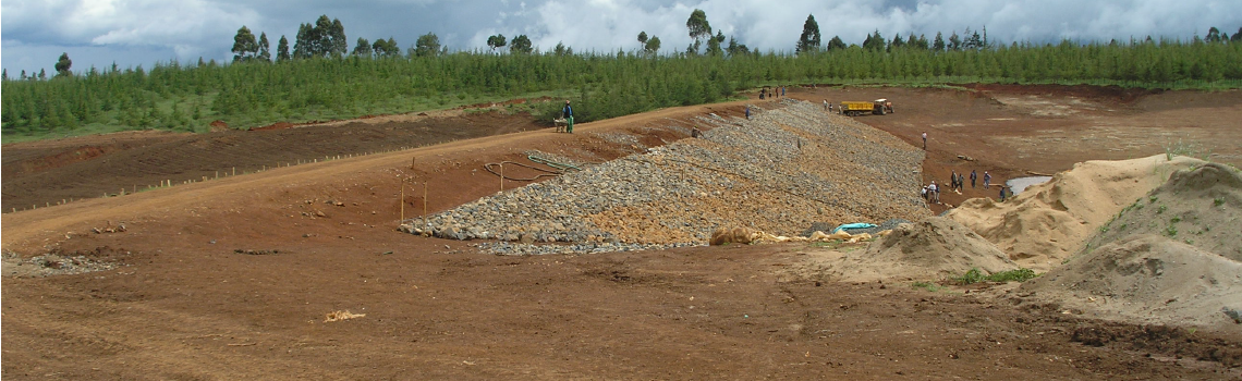
- The construction phase should ideally be conducted during the dry season to avoid disruption to construction by inclement weather. However, in arid areas, construction must also be scheduled when water is available and often must occur at the onset or tail end of the rainy season. Water is especially important for proper compaction of earth embankments and generally a water volume of 30% of the embankment volume will be needed during the construction phase.
3.6 Dam Safety Planning
The impoundment of water particularly by a dam forms a hazard so due consideration is required to the nature of the hazard, the risk of harm and/or damage, and mitigation measures that can be undertaken to minimise the risks.
The Emergency Action Plan (EAP) is a useful tool which helps to identify preventive measures which can reduce the scale of harm and damage in the event of a dam failure. The preparation of an EAP is now considered good practice for small dams that fall into a medium or high hazard class. The EAP should be developed by the dam owner/operator, in collaboration with other relevant parties as described below and should be maintained in a ready-state.
The EAP involves an analysis of the risks and anticipates an emergency that would necessitate immediate notification of government officials and downstream communities to minimise harm and damage downstream.
This material is drawn heavily from the “Federal Guidelines for Dam Safety: Emergency Action Planning for Dam Owners”, (Interagency Committee on Dam Safety, April 2004)
The EAP is a site specific document which covers the following components.
3.6.1 Notification flow chart
The notification flowchart provides the name, contacts, organisation, position and priority for those who should be notified and the cascade of responsibility for onward notification to other parties (Figure 3-2). The notification list should consider the following individuals and organisations:
- Dam owner and/or operator;
- Local emergency management offices;
- Local county and administration officials;
- Local police station;
- Water resource user associations;
- Downstream residents, water users and downstream dam owners/operators;
- Local Red Cross offices
- Media
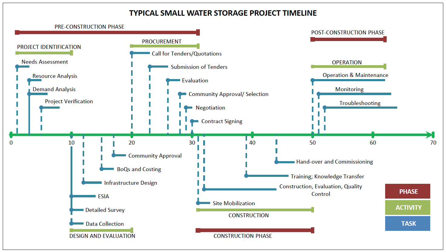
Figure 3-1: Typical Project Timeline
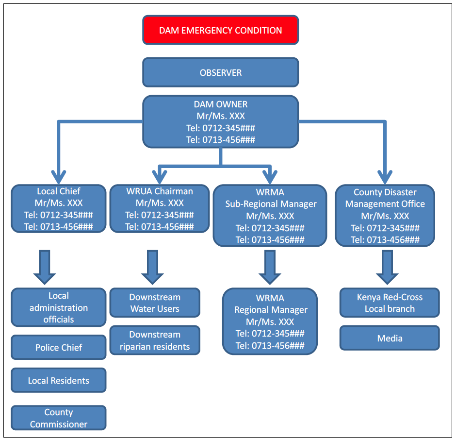
Figure 3-2: Sample Notification Flowchart
3.6.2 Project Description
A description of the nature, scale and location of the dam is provided, including a detailed map indicating access routes to the site. In addition, any upstream or downstream dams should be identified.
3.6.3 Emergency Detection, Evaluation and Classification
The EAP should include a description of the inspection and monitoring systems which are needed to ensure timely detection of an existing or potential emergency. These systems should ensure that competent persons, able to identify a problem, are involved in the inspection and monitoring procedures. In addition, the data and information required to help identify abnormal conditions should be provided.
Once an existing or potential emergency has been detected, it should be evaluated against the emergency classification system to establish the level of threat. The emergency classification system should use terms and conditions that are agreed by the dam owner/operator in conjunction with the county disaster emergency officials and which clearly indicate the urgency of the emergency condition. As the declaration of an emergency can be a controversial decision, the aim of the classification system is to provide a framework for quick decisions and actions.
Emergencies can be classified into three categories:
- Alarm Category. Failure is imminent or has just occurred. This condition implies that time has run out and immediate steps must be taken to notify and evacuate vulnerable downstream people. The implication is that corrective measures cannot prevent failure and the focus of attention should be on safeguarding lives;
- Alert Category. The alert condition applies if conditions are developing that could result in flooding downstream either due to dam failure or extreme floods. This condition implies that there is time to implement pre-planned actions to prevent or control failure, notify downstream inhabitants and protect infrastructure. A report of an Alert category emergency should indicate the expected time period before an Alarm situation arises.
3.6.4 Responsibilities
The EAP should clearly indicate the person and organisation responsible for the maintenance and operation of the dam and the persons responsible for implementing different components of the EAP, including co-ordinating the response.
- Dam Owner/Operator
The dam owner/operator holds the primary responsibility to see that the EAP is developed, up-to-date and that preparedness activities have been undertaken with all parties concerned.
- Responsibility for Notification
The notification flowchart indicates the person and details to be contacted when an emergency has been observed. The person contacted should have the authority to provide onward notification to third parties without having to seek authority as this can delay the dissemination of the notice.
- Responsibility for Evacuation
Evacuation is typically undertaken at the direction and supervision of government authorities. In this case the County Disaster Management Office will coordinate with the County administration to implement any evaluation plans. However, the dam owner/operator should be prepared to assist with evacuation activities, particularly in the vicinity of the dam.
- Responsibility for Duration, Security, Termination and Follow-Up
The EAP should provide details on the person responsible for real-time monitoring of the situation at the dam site to provide local authorities with up-dated information during and after the emergency. This information will help local authorities to be able to terminate the emergency.
- EAP Coordination
The EAP should identify the EAP Coordinator who should be a person with sufficient authority to revise the EAP should the need arise and be able to share emerging information with other parties.
3.6.5 Preparedness
The EAP should specify the preparedness actions that are planned and implemented under normal operating conditions. These preparedness actions may include:
- Providing real-time monitoring of reservoir levels and/or spillway releases in combination with pre-defined thresholds that trigger the emergence of an alert or alarm situation;
- Identification and preparation of normal and alternative access routes to the site and/or downstream inundation areas, including options to be followed during adverse weather conditions;
- Identification of backup systems to illuminate the site;
- Identification of alternate systems of communication should the mobile phone network be inoperative;
- Pre-positioning of emergency supplies, equipment and machinery that may assist in the prevention of or during an emergency;
- Anticipating emergency scenarios and providing specific information on steps to be taken within each scenario to reduce the threat and protect lives and infrastructure.
3.6.6 Inundation Maps
Inundation maps provide an estimate of the areas that may be inundated should a dam failure occur. The maps should provide specific information to the county disaster management offices regarding any settlements or specific infrastructure (roads, power lines, power stations, etc) within the inundation areas. The maps should clearly indicate the emergency scenario covered by each inundation map. For example, the inundation map should clearly show whether the scenario is a dam failure scenario or an extreme flood event as the inundation areas may be different depending on the scenario analysed.
3.6.7 Appendices
- Investigation and Analysis of Dam Break Floods
The EAP should identify and briefly describe the method and assumptions used to identify the potential inundation areas. Typically these assumptions will include items related to the nature of breach, the storage condition, time to breach, prevailing weather and inflow conditions, and flood routing.
- Plans for Training, Exercising, Updating and Posting the EAP
- Training. The EAP should include a training plan in which the individual to be trained are identified and the curriculum showing the specific information and tasks that the individual is expected to undertake. Scenario simulation provides a useful method to familiarise trainees with roles, information and responsibilities under the EAP.
- Exercising. A simulation of an emergency is an useful way to test out whether emergency procedures are ready for use. An evaluation of the simulation exercise is required to identify bottlenecks, areas of confusion or lack of appropriate information.
- Updating. The EAP should include a schedule for regular updating to ensure that all the contact information on the notification flow chart is correct and that all revised copies of the EAP are circulated.
- Posting The most recent version of the EAP Notification Flowchart should be posted in prominent places at the dam site, at the owner/operators office and at local offices for the county disaster management office, WRUA, and chief.
- Site Specific Concerns
This section of EAP should include any detailed information or drawings that relate to the dam structure and which may be useful during or after an emergency.
- Approval
The EAP should be approved by the dam owner/operator, WRMA, the County Disaster Management Office and local chief. This indicates that the main parties to the EAP have understood their responsibilities under the EAP.
3.6.8 Suggested EAP Format
The EAP should be structured to enable quick and easy reference to key information. A suggested format and outline is given in Chapter 19.
3.7 Common Problems in the Design, Construction and Rehabilitation of Small Dams
The purpose of the present guidelines is among others to address a number of frequently occurring problems regarding construction and rehabilitation of small dams and pans, which in most cases can be avoided or dealt with without necessitating the use of sophisticated means.
Therefore, the following points merit particular attention.
3.7.1 Hydraulic Failures
Hydraulic failures are reservoir failures caused by overtopping or surface erosion.
Overtopping: When free board of dam or capacity of spillway is insufficient, the flood water will pass over the dam and wash it downstream. The most important single technical reason why embankment failures occur in small earth dams in Kenya (and elsewhere) is insufficient spillway capacity (caused by either under-estimation of the flood flows, under-dimensioning of the spillway structure, lack of maintenance of the spillway or changes in the catchment characteristics). Insufficient spillway capacity can cause overtopping of the embankment with subsequent erosion of the downstream slope resulting finally in embankment failure. In order to avoid this problem, it is necessary to conduct a proper investigation of flood flows, and to determine the spillway dimensions accordingly.
In many cases the proper functioning of the spillway is seriously hampered by pronounced erosion, especially in the outlet channel. Apart from adequate design, including erosion protection measures where required, it is obvious that (especially for earth lined channels) regular inspection of the structure and prompt remedial action are indispensable to ensure correct functioning of the spillway.
- Erosion of downstream toe: The toe of the dam at the downstream side may be eroded due to i) heavy cross-current from spillway flows, or ii) tail water. When the toe of downstream is eroded, it will lead to failure of dam. This can be prevented by providing a downstream slope pitching or a riprap up to a height above the tail water depth Also, the side wall of the spillway should have sufficient height and length to prevent possibility of cross flow towards the earth embankment.
- Erosion of upstream surface: During winds, the waves developed near the top water surface may cut into the soil of upstream dam face which may cause slip of the upstream surface leading to failure. For preventing against such failure, the upstream face should be protected with stone pitching or riprap
- Erosion of downstream face by gully formation: During heavy rains, the flowing rain water over the downstream face can erode the surface, creating gullies, which could lead to failure. Erosion by wildlife and livestock can also lead to gully formation. To prevent such failures, the dam surface should be properly maintained; all cuts filled on time and surface well grassed. Berms could be provided at suitable heights and surface well drained.
3.7.2 Seepage Failure
Seepage always occurs in the dams. If the magnitude is within design limits, it may not harm the stability of the dam. However, if seepage is concentrated or uncontrolled beyond limits, it will lead to failure of the dam. Following are some of the various types of seepage failure.
- Piping through dam body: When seepage starts through poor soils in the body of the dam, small channels are formed which transport material downstream. As more materials are transported downstream, the channels grow bigger and bigger which could lead to wash out of dam. Piping is often caused by inadequate choice of construction material (soil). Location and choice of borrow areas should be carried out by experienced personnel. Heavy clays as well as soils containing a large percentage of sand are in principle not suitable for the construction of homogeneous embankment dams. Soils to be used as construction materials should also systematically be tested for dispersivity (See Section 8.4.4).
- Piping through foundation: When highly permeable cavities or fissures or strata of gravel or coarse sand are present in the dam foundation, it may lead to heavy seepage. The concentrated seepage at high rate will erode soil which will cause increase flow of water and soil. As a result, the dam will settle or sink leading to failure.
- Sloughing of downstream side of dam: The process of failure due to sloughing starts when the downstream toe of the dam becomes saturated and starts getting eroded, causing small slump or slide of the dam. The small slide leaves a relative steep face, which also becomes saturated due to seepage and also slumps again and forms more unstable surface. The process of saturation and slumping continues, leading to failure of dam.
3.7.3 Structural Failure
This is mainly due to shear failure causing slides along the slopes. The failure may be due to:
- Slide in embankment: When the slopes of the embankments are too steep, the embankment may slide causing failure. This might happen when there is a sudden drawdown, which is critical for the upstream side because of the development of extremely high pore pressures, which decreases the shearing strength of the soil. The downstream side can also slide especially when dam is full.
- Foundation slide: When the foundation of an earth dam is composed of fine silt, clay, or similar soft soil, the whole dam may slide due to water thrust. If seams of fissured rocks, such as soft clay, or shale exist below the foundation, the side thrust of the water pressure may shear the whole dam and cause its failure. In such failure the top of the dam gets cracked and subsides, the lower slopes moves outward and forms large mud waves near the dam heel.
- Faulty construction and poor maintenance: When during construction, the compaction of the embankment is not properly done, it may lead to structural failure.
3.7.4 Operational Failure
Failure of a reservoir to fill or excessive siltation can be considered as operational failures.
- Rapid siltation: Siltation of reservoirs can best be addressed through a catchment wide program of erosion prevention and soil conservation, but a considerable number of problems can be avoided (or at least alleviated) by a considered choice of the dam location, avoiding wherever possible rivers with excessive silt loads.
- Evaporation: Significant water losses through evaporation can be a concern. As a general rule, and with the possible exception of reservoirs solely intended for the supply of livestock during part of the year, care should be taken not to construct very shallow reservoirs (water depth <3-4 metres) in areas of high potential evaporation. Other possibilities (e.g. sub-surface dams) should be considered carefully if excessive water losses through evaporation are expected.
- Lack of inflow: Lack of inflow can result from inaccurate estimation of catchment runoff or from construction of storage or other water infrastructure upstream in the catchment. Future catchment development plans should be considered before committing to storage projects.
- Lack of maintenance: The operation, maintenance and training aspects of completed and ongoing small earth dam projects often receive insufficient attention, while public awareness and participation of the involved communities is often inadequate. This results in rapid degradation - and even partial destruction - of completed structures due to easily avoidable causes: cattle is left to wander up earth embankments and into the reservoir thus wearing out the embankment and damaging fences, while severely polluting the reservoir water; trees are left to grow on the embankment (large roots in the embankment will create preferential seepage paths for the water): nothing is done about beginning erosion -by rainfall or run-off in the spillway and on the embankment; high vegetation is left thriving in the spillway channel, thus hampering the spillway discharge capacity etc.
4. Policy And Legal Compliance
This chapter sets out the policy and legal framework for the development of water conservation structures. These are principally defined by the policy and laws governing the water and environment sectors.
4.1 Policy on Water Storage
The National Water Harvesting and Storage Management Policy1 (May 2010) is the current MWIS’s policy on water storage. Notwithstanding that the policy has not been gazetted as a sessional paper which provokes debate regarding its legal validity, the policy does set out the MWIS approach to issues related to water storage development.
The policy objectives are to:
- Provide a framework for expansion of infrastructure for national water storage capacity from the current 124 M to 4.5 B to ensure an increase in per capita storage from 5.3 to 16 over the next ten years.
- Improve participation in planning, financing and investment by communities, development partners, NGOs, PPPs, and other stakeholders’ contributions.
- Create an enabling environment for the participation of farmers and/or land owners, water user groups, and all water sector stakeholders in planning, implementation and management of water harvesting, storage and flood infrastructure.
- Enhance flood mitigation preparedness in affected areas.
- Build human resource capacity to enhance innovation, research, science and technology, adoption and management of water harvesting and storage systems and flood control structures.
- Enhance stakeholders-driven multi-sectoral approach to sustainable water harvesting and storage systems and flood control structures, as well as expansion and protection of water catchment areas.
- Ensure integrated coordination of stakeholder activities for development of water harvesting, storage and flood control infrastructure; and
- Establish responsive institutional, legal, and regulatory framework for water harvesting, storage and flood control.
The policy’s guiding principles are as follows:
On the development of infrastructure, the policy principle is that the Ministry and other stakeholders shall undertake water harvesting and storage infrastructure planning, design, development and management based on the latest innovations, research, science, technology, information, and management and make use of the most appropriate and cost-effective best practices to optimize sustainability.
On regulation the policy principle is that every water harvesting, storage and flood control project shall be registered with the government institution responsible for water storage and flood control.
On the issue of effective management the policy principle is that the implementation of water harvesting, storage and flood control systems shall be optimally and efficiently managed to ensure sustainable economic returns and social enhancement.
On licensing the policy principle is that every individual and institution responsible for design, development, implementation and management of water harvesting, storage and flood control structures shall acquire relevant permits, authorizations and licenses (where applicable) from relevant government agencies or any such agency as may be proscribed by law from time to time.
On general responsiveness, equality and equity the policy principle is that planning and implementation of water harvesting and storage systems and flood control programmes shall embrace equality and equity while being sensitive to gender and the specific needs of the youth, minority groups including persons with disabilities, orphans, and other vulnerable and marginalized groups in communities in targeted areas.
On partnerships the policy principle is that effective partnerships shall be developed in all stages of planning and implementation within the framework of the Integrated Water Resources Management (IWRM).
On ecological stability the policy principle is that when implementing water harvesting, storage and flood control programmes, water institutions and water-related agencies shall take into account ecosystems’ integrity and resilience, and biodiversity and environmental conservation.
On access to water resources the policy principle is that every household and institutional needs for water including domestic, livestock, crop agriculture, aquaculture, irrigated agriculture, commercial, industrial, social, environmental services and other uses shall be taken into account.
On access to health services, the policy principle is that every individual has a right to have access to safe drinking water and adequate sanitation, in an environment of reduced incidences of water-borne and water-related diseases and incorporation of public health aspects in the development of water harvesting, storage and flood control systems.
On disaster responsiveness the policy principle is that planning and implementation of water harvesting, storage and flood control structures shall incorporate disaster preparedness and management to enable households and institutions to cope with and mitigate the impacts of cumulative climate variability, and natural disasters.
On ethics the policy principle is that planning and implementation of water harvesting, storage and flood control programmes shall be ethically executed within recognized and proscribed institutional and legal frameworks, to be created under this policy.
On governance the policy principle is that planning and implementation of water harvesting, storage and flood control systems shall recognize cross-cutting aspects and shall be guided by the principles of transparency, accountability, and good governance inscribed within the rule of law.
Finally the policy is to be implemented through the existing water laws and regulations governing the management of water resources.
The national water harvesting and storage policy is supplemented by policies on water resources management, land use planning, irrigation, forests, land degradation, livestock and environment, all of which must be taken into account in considering the applicable policy framework.
4.2 The Legal Framework
The legal framework comprises laws and regulations governing the natural resources sectors. The overarching law is the Constitution of Kenya 2010. Article 43 deals with economic and social rights and includes the right to clean and safe water in adequate quantities as a fundamental human right. The state therefore has an obligation to ensure that every Kenyan has access to clean and safe water, which makes it imperative that the state put in place measures and frameworks for making water accessible, through dams and other storage infrastructure among other measures.
The Constitution also puts in place the applicable institutional framework. It establishes two levels of government: the national government and county governments. The Fourth Schedule allocates functions to the two levels of government. The national government has the mandate over:
- the use of water resources;
- water protection;
- securing sufficient residual water;
- hydraulic engineering;
- the safety of dams; and
- disaster management.
The county government has the mandate over soil and water conservation and county public works and services including water and sanitations services under which would fall the construction of small dams and small storage facilities for water services purposes.
The current water law is the Water Act 2002 which governs the water sector. The Government has however presented to Parliament the Water Bill 2014 to align the provisions of the water law to the Constitution of Kenya 2010. The Government has also developed a revised water policy which has not yet been adopted as a sessional paper.
Other components of the legal framework are laws governing the sectors on environment, forest, wildlife, agriculture, land use planning and regional development, county government and the management of public finances.
Regarding the private sector there are laws governing the provision of services by professional engineers, contractors and other service providers. The Government has put in place a legal framework for procurement of professional and other services and this procurement system would apply if the dams and small structures are being financed by a public agency or out of public funds.
4.2.1 Water Allocation
Water allocation is governed by the provisions of the Water Act 2002. The responsibility for water allocation lies with the Water Resources Management Authority (WRMA). Under section 8 of the Water Act, 2002 one of WRMA’s functions is to develop principles, guidelines and procedures for the allocation of water resources.
The Water Act itself sets certain key principles which set the parameters for water allocation as follows:
- Through the national water resources management strategy WRMA shall determine the requirements of the reserve for each water resources. This determines the water available for allocation.
- Water resources are to be classified, which will affect The class of water resource is important in determining the use to which it may be put, including whether and the extent to which impoundment and abstraction is permissible.
- Provision is made for designating areas as protected areas and ground water conservation areas, which limits the allowable activities within the area.
In addition to the national water resources management strategy there will be for each catchment a catchment area management strategy (CMS) which will, among other aspects:
- Contain water allocation plans and set out the principles for allocating water in the catchment.
- Contain mechanisms for stakeholder consultation.
Any project to construct facilities for small dams and other water conservation structures needs to take account of both the national water resources management strategy and the applicable catchment area management strategy in so far as they relate to the allocation of water resources for the project.
Other key principles which give priority in the allocation of water resources are:
- The use of water for public purposes (including storage or impoundment of water for bulk distribution take priority in the allocation of water resources).
- The use of water for domestic purposes takes precedence in the allocation of water over the use of water for other purposes.
Finally it is important to note that water resources will only be allocated on the basis of availability; compliance with conditions set by WRMA to secure the similar right of other users downstream; construction of structures which meet the standards set by WRMA; and the payment of a water use charges.
4.2.2 Requirement for a Permit
The Water Act 2002 imposes a requirement for a permit on any person wishing to acquire a right to use water from a water resource. Section 27 makes it an offence to construct or use works to abstract water without a permit. There are however three exceptions to the permit requirement. These are cases of:
- minor uses of water resources for domestic purposes (representing uses of water for domestic purposes abstracted without the assistance of equipment) ;
- uses of underground water in areas not considered to face groundwater stress and therefore not declared to be groundwater conservation areas; and
- uses of water drawn from artificial dams or channels, which – being artificial rather than natural - are not considered to be water resources of the country.
The application for the permit is made to WRMA. Section 32 stipulates the factors to be taken into account in considering an application for a permit. These include:
- The existing lawful uses of the water.
- Efficient and beneficial use of the water in the public interest;
- The likely effect of the proposed water use on the water resource and on other water users;
- The strategic importance of the proposed water use;
- The probable duration of the activity for which the water use is required;
- Any applicable catchment management strategy; and
- The quality of water in the water resource, which may be required for the reserve.
It is expected that WRMA will also take into account any requirements imposed by international agreements related the catchment relevant to the water permit application.
These considerations are designed to enable WRMA balance the demands of competing users, but also to take into account the need to protect the general public interest in the use of water resources as well as the imperative to conserve water resources.
Further guidance is given to the Authority in deciding on allocation of the water resource as follows:
- That the use of water for domestic purposes shall take precedence over the use of water for any other purpose and, in granting a permit, the Authority may reserve such part of the quantity of water in a water resource as is required for domestic purposes. It is to be recalled that, in rural settings, use of water for domestic purposes typically includes use for small dams, water pans and similar structures; and
- That the nature and degree of water use authorized by a permit shall be reasonable and beneficial in relation to others who use the same sources of supply.
Permits are given for a specified period of time. Additionally, WRMA is given power to impose a charge for the use of water. Details of the charges to be imposed, including the amounts to be charged, and the uses for which a charge may be imposed are spelt out in the Water Resources Management Rules, 2007, which should be consulted before proceeding.
Permits run with the land. Where the land is transferred or otherwise disposed of, the permit also passes to the new owner of the land. Section 34 requires that a permit specify the particular portion of any land to which the permit is to be appurtenant. Where the land on which the water is to be used does not abut on the watercourse the permit holder must acquire an easement over the lands on which the works are to be situated. It is thus not possible, under the law, to obtain a permit in gross (i.e., which is not linked to particular land).
In all cases of construction of new small dams or pans, an application for a Water Permit should be filed with WRMA. Where small dams and pans are rehabilitated, it should be examined on a case to case basis whether the existing Water Permit (if any) is still relevant to the situation after rehabilitation. Where no Water Permit has been issued or when the situation after rehabilitation will vary from the terms and conditions on which the original permit was issued, the required steps must be taken to either obtain a Water Permit or to have the old Water Permit revised.
Water Permits are issued by WRMA to which applications must be submitted. Every applicant for a Water Permit must complete and file with WRMA the following documents in triplicate, accompanied by the prescribed fee:
- An application in the prescribed form together with plans or drawings, which will allow all requisite details to be legibly recorded;
- An application to construct the required works.
The following forms are prescribed by the Water Act for the purpose of filing the above mentioned applications:
- Form No. WRMA 001A: Application for a Water Permit;
- Form No. WRMA 001B: Surface Water covering Diversion, Abstraction, In-stream and Conveyance Works;
- Form No. WRMA 001C: Storage Dams
4.2.3 Permit Classes
The Water Resources Management Rules 2007 provide for the following classes of water use permits:
- Class A: low risk water use
- Class B: potential to make a significant impact on a resource
- Class C: significant impact on water resource;
- Class D: involves two different catchment areas, is of a large scale or complexity
An application for a water permit for a dam or storage reservoir will need to ascertain the category of dam as described in Table 4-1 from the Fourth Schedule, Water Resource Management Rules (2007).
Table 4-1: Classification of Dams
| Class of Dam | Maximum depth of Water at NWL (m) | Impoundment at NWL ($m^3$) | Catchment Area ($km^2$) |
|---|---|---|---|
| A (Low Risk) | 0 – 4.99 | < 100,000 | < 100 |
| B (Medium Risk) | 5.00 – 14.99 | 100,000 to 1,000,000 | 100 to 1,000 |
| C (High Risk) | > 15.00 | > 1,000,000 | > 1,000 |
Having decided on the category of dam, the applicant must determine the appropriate class of permit using Table 4-2.
Table 4-2: Relationship between Category of Dam and Class of Permit
| Type of Structure | Category of Dam | Class of Permit |
|---|---|---|
| Pan (tank, lagoon, etc) whose capacity exceeds 10,000 m3 | A | |
| Dam with normal water level no greater than 1.5m above ground level | A | |
| Small Dam | Class A | B |
| Medium Dam | Class B | C |
| Large Dam | Class C | D |
(Source: WRMA 2009. Guidelines for Determination of Permit Classification for Water Storage Structures)
4.2.4 Water Permit Application Process
The required forms may be obtained from the office of the nearest Regional or Sub-regional Office of WRMA. The applications must be completed and filed in triplicate together with all relevant plans and drawings as well as a copy of the design report. A fee covering the examination of the application and the issue of a permit must be paid in accordance with the quantity of water for which the application is made. The actual fee is dependant on the Category of Permit.
Upon receipt of an application, WRMA may amend or vary the application, maps or plans. The law requires stakeholder consultation before the grant of the application. This usually will involve the input of the Water Resources Users Association in cases where there is a WRUA in the area. The WRUA comments should be documented on WRMA Form 003 and submitted to WRMA. In contentious cases a full public hearing of the application may be required.
There may also be a need for an Environmental Impact Assessment, depending on whether the structure requires a full EIA study under the Environmental management and Coordination Act, 2009. This will require consultation with the NEMA office in the county.
WRMA may, after consideration finally approve, refuse or approve the application in part. If the application is finally approved, WRMA shall consequently authorize the construction of the works. In such case, a copy of the application, with maps and plans as approved shall be returned to the applicant with the authorization.
Any works authorized may be inspected, during construction, by officers of WRMA. Upon completion of the works authorized, the operator shall submit a completion certificate (Form No. WRMA 008), upon which an inspection may be made by an officer appointed by WRMA.
Upon completion of the works and in accordance with the terms of the authorization, WRMA shall issue on such terms and conditions as it may deem necessary a permit to divert, abstract, obstruct, use or store the quantity of water for which the application was finally approved.
4.2.5 Requirement for Hydrological Assessment Report/Dam Design Report
Rule 64 of the Water Resources Management Rules 2007 requires a dam design report to be submitted as part of the application documentation. The form of the design report is provided in the Second Schedule. The report shall be approved by WRMA prior to construction. The rules state that the level of detail of the report depends on the class of dam and so will vary from case to case.
In addition to the dam design report the Rules require a hydrological assessment report. The specifications of the report are provided in the Second Schedule and these should be reviewed by the professional preparing the report before embarking on the assignment.
In addition it is important that an analysis is undertaken in the context of the EIA approval of the potential environmental impacts of the dam. This analysis may also include the determination of the Reserve or environmental flow requirements.
Rule 57 states that a dam shall be designed and supervised by the appropriate category of qualified water resource professional as set out in Table 2 of the Fourth Schedule.
Rule 58 states that a dam shall be constructed by the appropriate category of contractor as set out in Table 3 of the Fourth Schedule.
Finally Rule 66 requires the filing of a dam completion report with WRMA. The form of the report is set out in the Second Schedule and a completion certificate is to be issued by WRMA.
4.2.6 Requirement for Qualified Water Resource Professional
Rule 57 of the WRM Rules 2007 specifies that a qualified water resource professional shall be used to design and supervise the construction of a dam as specified in Table 2 of Schedule 4. This applies regardless of whether the project is a state, community or private endeavour.
The registration of water resource professionals is dealt with in Rules 132 to 140 of the WRM Rules 2007. It gives the criteria to be met by individuals who wish to be registered as qualified water resources professionals, the application process, licensing and regulation of professionals, including the procedure for lodging complaints against professionals.
The MWIS maintains a register of qualified professionals and this should be inspected before engaging a professional to undertake an assignment involving a dam construction. The use of qualified professionals enhances the quality of the work and minimises the risk of dam failures.
4.2.7 Requirement for Qualified Contractor
Rule 58 of the WRM Rules 2007 also require that qualified contractors are used to construct dams. The category of contractor is set out in Table 3 of the Fourth Schedule. This applies regardless of whether the project is a state, community or private endeavour.
The registration status of a contractor should be verified before engaging the contractor. Additionally the National Construction Authority Act, 2012 requires contractors to be registered with the Authority in order to undertake construction. The register of contractors showing the category of works they are registered for is published in the Gazette. It is possible to obtain a copy of the register from the Authority but additionally the contractor should be asked for evidence of registration.
4.2.8 Requirement for Regular Inspections
During construction, a dam construction progress report is required to be submitted to WRMA at such intervals as WRMA requires, as per Rule 65 of the WRM Rules 2007. Rule 93 gives WRMA the authority to inspect the works at any time, prior to, during or after construction.
4.2.9 Fines and Penalties for Offences under WRM Rules
The Third Schedule of the WRM Rules (2007) sets out the fines and penalties for offences committed against the Rules.
4.3 Policy on Environmental Management
Dam construction is also governed by environmental policies and laws. The current environmental policy is the National Policy on Environment and Development, 1999. The key policy principle relates to sustainability in the use of natural resources. The policy was given effect by the National Environmental Management and Coordination Act, 1999.
4.4 Environmental Laws and Regulations
The National Environmental Management and Coordination Act, 1999 is the main legal instrument on environmental management. The Act establishes the National Environmental Management Authority (NEMA) as the key coordinating institution on environmental management in the country. The Act also provides that other agencies with statutory functions in the natural resources sector are lead agencies, meaning that they will take the lead in implementation of environmental policies and laws, within the context of their mandate. WRMA is therefore a lead agency under EMCA, 1999 for purposes of issuing permits and regulating dams and small water structures.
Under the Act regulations have been gazetted to give effect to the provisions of the act. The key ones are:
- The Environmental Management and Coordination (Environmental Impact Assessment and Audit) Regulations LN No 101 of 2003
- The Environmental Management and Coordination (Waste Management) Regulations LN No 121 of 2006 which deals with the handling of waste products and
- The Environmental Management and Coordination (Water Quality) Regulations LN No 120 of 2006 which stipulates water quality standards.
4.4.1 EIA Permit
Section 58 of the Environmental Management and Coordination Act, 1999 imposes a requirement for any project proponent to obtain an EIA licence from NEMA before undertaking a development project. Dams would therefore require an EIA licence. The EIA report is to be prepared by an EIA expert who is registered with NEMA. The proponent of the dam project is required to choose a NEMA registered EIA expert to prepare the report. Additionally a fee is paid to NEMA for the licence.
The EIA process should identify the potential environmental impacts of the dam and propose mitigation measures which can address these impacts. The EIA process also requires stakeholder consultation.
4.4.2 EIA Permit Application Process
The application for an EIA licence begins with the preparation of a project report which gives a brief description of the project. The report enables NEMA to determine whether the project will have significant impacts on the environment. If so then a full EIA study will be required otherwise an approval can be issued based on the project report.
Where a full EIA study is required the project proponent is required to engage a registered EIA expert to undertake the study according to Terms of Reference agreed with NEMA. The study involves gathering data to establish the baseline, carrying out public consultation and analysing the information to determine impacts. Where adverse impacts are anticipated then mitigation measures need to be proposed.
NEMA is required to send the report to lead agencies for their input. Additionally NEMA will make public the fact that a licence has been applied for and invite comments. Where the application raises objections a public hearing may be held. Where there are complex issues NEMA may appoint a technical advisory committee to advise it.
If approved NEMA will issue a provisional approval and subsequently issue a licence for the works.
The requirement for an EIA licence must be complied with in addition to the requirement for a water use permit. The issues arising in the two processes may be very similar but in the case of EIA licensing ecological and environmental sustainability issues may arise which go beyond the water use issues.
NEMA maintains offices at the county level where there is a county and sub county environmental officer. These officers should be consulted to facilitate the process of EIA licensing.
4.5 Land and Trespass Laws and Regulations
The current land laws are found in the Land Act, 2012 and the Registration of Land Act 2012. Under the Land Act land is either public land, private land or community land. Private landowners have evidence of ownership, which is either a certificate of title or a certificate of lease. A formal search from the land registry to confirm ownership is important.
For a dam project access to and use of land is critical. Therefore an agreement ought to be reached with the landowner regarding the use of land. The landowner may sell the land to the project, in which case a transfer is registered in the name of the dam owner. Even if a transfer is not agreed to some formal documentation recording the landowner’s agreement to the use of the land is essential.
In several cases the landowner is the government, the county government or the community who have agreed to allow the land to be used for the dam. In these cases a transfer of the title to the dam owner is not likely but some letter of authority to use the land should be obtained.
Securing land access and rights of investigation and development may require arranging for a wayleave (or easement). Where access is required over another person’s land then a wayleave will be necessary. This is formal permission to cross over someone’s land, using pipes of some other infrastructure. Wayleaves are often paid for and recorded on the title so that they bind the owner. Obtaining wayleaves can at times be problematic. The Water Act 2002 provides a procedure for seeking WRMA’s intervention in cases where the landowner proves unreasonably difficult to grant a wayleave.
4.6 Liability and Indemnity
Where there is damage to another’s property, say from failure of a dam, the dam owner may face a claim and be liable to pay compensation. This may require that the dam owner take out insurance. Additionally the dam owner may require the professionals and the contractor involved in the project to provide an indemnity in the event that the damage has arisen from professional negligence in the design or construction or similar failing. For this purpose the professionals will be required to take out professional indemnity insurance cover. The contractor will also take out an appropriate insurance cover.
4.7 Procurement Regulations
If public money is being used to carry out the project it is necessary to follow public procurement regulations. These are found in the Public Procurement and Disposal Act, 2006. These require that the public agency undertaking the project use competitive tendering to secure the service providers. There are limited cases in which competition is not required but it is important to remain complaint as the contract award can be nullified if the law is not complied with.
If the project is supported by donor funds, the project proponent should check if public or donor procurement laws apply. At times donor procurement laws can be quite stringent and it is important to familiarise oneself with them if the funds are being provided by a donor.
If the project is a private endeavour, using private funds, the owner can decide how she/he procures an engineer and contractor but he/she must still contract engineers and contractors that fulfil the legal requirements.
4.8 Other Relevant Laws and Regulations
Labour laws will govern the labour practices that the contractor must comply with during construction. Therefore the contractor must be familiar with the requirements of the labour laws and occupational safety and health laws. These can lead to criminal and civil liability if they are not complied with and delay the project.
5. Stakeholder Engagement And Community Participation
5.1 Introduction
Successful development of safe, economically and environmentally appropriate small dams, pans and other water conservation structures, like any other development project, demands the active participation of stakeholders to ensure proper coordination, planning, smooth implementation, and sustainable benefits. The importance of actively developing and sustaining relationships with affected communities and other stakeholders throughout the life of such projects has proved beneficial in risk management and has delivered better project outcomes.
This chapter details the basis, requirements, importance and process of stakeholder engagement that can be applied in developing cooperation with stakeholders during the design, construction, operation and rehabilitation of water conservation structures. It is however important to ensure that such community participation and engagement takes cognizance of how participation is captured in the diverse communities in Kenya. In some cultures in the ASAL regions of Kenya, for example the Deda system for range management and the Abba Herega at a point source, have legitimacy at community level but often lack official recognition and hence cannot enforce their rules.
Additionally, it is important to note that since the 1990’s great strides have been made in the area of public participation. This has culminated in the development of legislation, policies, strategies and tools for stakeholder engagement that were either previously not in place or not well developed. There now exist diverse strategies and tools for stakeholder engagement and thus the description of a strategy or tool in this manual should not in any way limit the users of the manual from using or applying other available, effective strategies and tools; the idea is to ensure that the key steps of stakeholder identification, analysis, engagement and monitoring are done.
Reference should be made to other documents that provide more detail on building capacity within communities to manage their water supplies which include the local dams, pans and other water conservation structures.
This chapter is primarily orientated towards public projects in which the local community are the beneficiaries of the structure being developed. However, the process of stakeholder analysis and engagement is equally applicable to private projects even though the local community may not be the direct beneficiaries of the proposed water conservation structure.
Additional reference can be made to the WSTF documents associated with the Community Project Cycle (CPC), the WRUA Development Cycle (WDC) and the UNICEF, FAO and Oxfam GB (2012) document A Trainers Manual for Community Based Water Supply Management in Kenya which provide tools for stakeholder engagement.
5.1.1 Objectives of Stakeholder Engagement
The principle objectives of stakeholder engagement are to:
- Ensure effective co-ordination of the project with different sectors and players;
- Introduce a range of ideas, experiences and expertise from stakeholders which motivates development of lasting and improved water conservation structures that incorporate all stakeholders interests;
- Build consensus between the projects and community members to mitigate potential risk of conflicts which can be detrimental to the success of the water conservation project.
- Utilize existing opportunities and relationships to enhance project outcome;
- Foster local pride and ownership among project stakeholders.
5.1.2 Classification of Stakeholders
A stakeholder is any person, group or organization who can be positively or negatively impacted by or cause a positive or negative impact on a proposed water conservation project. There are two key classifications of stakeholders as follow:
Primary Stakeholders:- These are persons, groups or organizations that are directly affected by the project either as beneficiaries (positively impacted) or de-beneficiaries (negatively impacted), sometime referred to as a Project Affected Person (PAP). This could for example include various water users of the proposed structure.
Secondary Stakeholders:- Persons, groups or organizations that are not directly affected by the project but have an intermediary role in the project and may thus have an effect on the project outcome. This could include stakeholders such as government ministries and departments, regulatory bodies, development organization, among others who have a stake in the proposed water conservation structure.
Persons, groups or individuals from either group who can significantly influence or are important to the success of the project are further referred to as Key Stakeholders. This group may include local opinion leaders such as local political leaders (e.g. MCAs) and ward administrators.
5.2 Legislative Basis for Community and Stakeholder Participation
Stakeholder engagement is not only a positive strategy for enhancing water conservation projects success but also a legal and ethical requirement. The following is a brief description of some of the existing laws and policies that demand stakeholder engagement.
-
The Constitution of Kenya 2010 has captured public participation of its citizens under national values and principles of governance (Chapter 2). The Bill of Rights (Chapter 4) further provides for among others the right to freedom of expression (Article 33) and the right to access to information, and the protection of all right and fundamental freedoms.
The Constitution of Kenya 2010 also introduced the county government structure necessitating changes in engagement with a new set of stakeholders. The county ministries or departments for the time being charged with the responsibility of water supplies and land at county level will need to be fully involved in the siting, designing, planning and bestowing of community ownership of the water conservation facilities within the context of the county laws and in line with the national laws.
Participation of the community in the processes of planning and design will then be ensured through the legal and social framework overseen by these departments. The rights and responsibilities of the community must be discussed and agreed in a structured way and formal registration of a community based organisation (or dam management committee) ensured within the prevailing legal framework.
In light of the dictates of the Constitution of Kenya 2010 governance of WRUAs and other water associations has also changed. While previously a group of community members could register themselves as owners of a community asset such as a dam and take charge, the new dispensation now requires that such an arrangement is officially sanctioned by the county government department in charge of water supplies. The mandate will be a delegated responsibility by the county government especially if the location of the dam or other water conservation structure is on public or community owned land and if the group is formed to manage the dam on behalf of the wider community. Each county will have its own process of registering and recognizing such a group and how to monitor its management of the dam as a public asset.
- Water Act 2002 makes provisions for the formulation, through public consultation, of a catchment management strategy for the use, development, conservation, protection and control of water resources within a catchment area (Section 15). Section 16 further provides for the constitution of a catchment area advisory committee (CAAC) with membership of diverse stakeholders within the catchment areas. At a local level, the WRUA membership should reflect the key stakeholders of water users within a sub-catchment and should therefore be considered during stakeholder analysis and consultation for the project.
- The Environmental Management Coordination Act (EMCA) imposes the need for an Environmental and Social Impact Assessment (ESIA) for all public and private water storage infrastructure projects. The ESIA is dealt with in more detail in Chapter 6. However, in certain projects a public or non-government body has the role of project owner, project manager, and/or project beneficiary and must fulfil the requirements of the Environment Management and Coordination Act (EMCA).
-
The Community Land Bill, 2013: deals with structures erected on community land. The small dams, pans and other water conservation structures dealt with in this manual will be located on land that is either communally owned (held in trust by county government) or privately owned. Article 14(3) of the Community Land Bill, 2013 states that, until any parcel of community land has been registered in accordance with this Act (Community Land Act – yet to be enacted), such land shall remain unregistered community land and shall be held in trust by the county government on behalf of communities pursuant to Article 63(3) of the Constitution. However, once an unregistered community land is registered in accordance with this Act, the trusteeship role of the county government shall lapse and the community group registered in relation to such land shall, through its relevant committee, assume the management and administrative functions provided in this Act. The Bill provides a mechanism for the management of community land. Article 18(1) states that every community shall through election by the community assembly, establish a Community Land Management Committee. On land use planning, Article 36 (1) of the draft Bill states that a Committee may, on its own motion or at the request of the county government, submit to the government for approval a plan for the development, management and use of the community land vested in the management of the Committee.
In light of the above, where the small dams, pans and other water conservation structures are to be constructed on community or public land, due process should be followed as contained in the laws above to ensure that the ownership is secured for the said asset before construction begins. If the dam – a public asset - is to stand on privately owned land, the community should insist on the owner of the land signing a lease with the community before construction works begin.
-
The Dublin Statement on Water and Sustainable Development are also known as the Dublin Principles. This statement recognizes the increasing scarcity of water as a result of conflicting water uses and the overuse of water. The statement sets out the following four guiding principles as recommendations for action at local, national and international levels to reduce water scarcity:
- Fresh water is a finite and vulnerable resource, essential to sustain life, development and the environment;
- Water development and management should be based on a participatory approach, involving users, planners and policy makers at all levels;
- Women play a critical role in the provision, management and safeguarding of water;
- Water has an economic value in all its competing uses and should be recognized as an economic good.
5.3 Key Concepts in Community Participation
5.3.1 Sustainability
In order to achieve sustainable projects (in the case of small earth dams, pans and other water conservation structures, the structure should have a useful lifetime of 20 to 25 years) the beneficiaries should be actively involved in the planning, construction and particularly operation and maintenance of the facility. Sustainability for a small earth dam or pan is being achieved when:
- The water sources are not over-exploited but are naturally replenished;
- Water systems are maintained in a condition which ensures a reliable and adequate water supply;
- The benefits of the supply continue to be realized by all users indefinitely;
- The service delivery process demonstrates a cost-effective use of resources that can be replicated;
- The water supply system is maintained in a condition which is able to provide water services to meet the needs of the growing population and increasing water demand without external support.
5.3.2 Community Empowerment
Community members must develop and maintain structures for holding their leadership accountable as part of self-governance. But this also comes with community members’ understanding of their own responsibilities for the management of the asset. Some possible structures of accountability are included in Table 5-1:
Table 5-1: Possible Accountability Structures
| Issue | Management Indicators | Community Action/checks |
|---|---|---|
| Financial Management | ||
| Accountability | Proper book keeping issue receipts against payment for water, invoices for all payments made, stock book etc | Establish this system from onset and develop system of auditing by members (users) |
| Appropriation of funds | Budgets and proposals to donors and potential benefactors | Discuss and agree actions |
| Water charging | Up to date records | Ensure the committee maintains paperwork and make it available for inspection |
| Leadership | ||
| Elections | Registered Community Dam Constitution Fair elections procedures defined within constitution and followed | Insist on term limit for office and democratize and ensure regular election of leaders |
| Communication | Minutes of meeting shared | Insist that decisions taken by committee are minuted and disseminated to users by posting on a public place Annual general meeting where community can question the leadership on decisions taken on their behalf |
| Equity in leadership | Gender & stakeholder balance in the committees | Insist on one-third gender rule in leadership as the very minimum |
| Lack of legal redress in dealing with corruption | Bylaws high lighting action against misuse of office | Insist that WUA registers as Society under the Societies Act and initiates process to become a WSP. |
| Poor service levels/user dissatisfaction | ||
| Lack of equitable access to water | Byelaws provisions in regard to equity | Ensure that byelaws are appropriate, have been agreed by the whole community and are followed |
| Larger livestock owners not paying in proportion to the amount of water they use or abusing the facilities | Byelaws provisions in regard to equity; Develop specific facilities (troughs) for livestock and enforce their use | Public auditing of accounts and comparing revenue against production by use of water meters as a means of quantifying unaccounted for water. |
| Conflict between users | Byelaws provisions in regard to conflict resolution | Mechanisms for conflict resolution should be articulated within byelaws. |
5.3.3 Inclusivity and Gender Balance
Inclusivity is another essential aspect of the new constitutional dispensation. While prior to 2010, it would be acceptable to put together a leadership team of any community or national institution without due regard to gender balance, the constitution now puts a threshold for participation of all gender in leadership. Especially in rural and ASAL communities, women are traditionally the most knowledgeable regarding domestic water needs as well as the main family providers of domestic water and yet are most often overlooked when leadership is being constructed. Where tradition works against women engaging in leadership with men, it is important to interrogate the traditions and find a way to ensure the constitutional minimum threshold of two-third gender rule ensuring that marginalized groups do not only belong to the committees but are elected to positions of authority within the committees.
5.4 Stakeholder Analysis
Effective engagement of beneficiaries in any project starts with a thorough analysis of project stakeholders. Stakeholder activities can either enhance or undermine the operations of a project while the project on the other hand can also impact the stakeholders positively or negatively. It is therefore important that before the project starts, its stakeholders are properly identified and analyzed, and their level of involvement or how the project will affect them or their operations is described and ways of engaging with them developed. Stakeholder analysis involves three key steps:
-
Identification of the key stakeholders from the large array of groups and individuals that could potentially affect or be affected by the proposed intervention.
This process can be initiated by indiscriminately listing all stakeholders likely to be affected or affect the proposed project. Prioritization of the stakeholders listed can then be done through consultation with experts within and outside the community to come up with the list of key stakeholders.
-
Assessment of stakeholder interests and the potential impact of the project on these interests as well as the influence of the identified stakeholder on the project. Influence in this case refers to the power that a stakeholder has over a project and thus the significance of their involvement in the project.
Once the key stakeholders have been identified, the possible interest and influence that these groups or individuals may have in the project will then be considered and assessed. Stakeholders are typically categorized into one of four groups as follows:
- Stakeholders of high influence and high interest: They need to be closely engaged throughout the preparation and implementation of the water conservation structure project. Collaborative and empowering approaches should be thus adopted with this group. Caution also ought to be taken of stakeholders in this group who have strong opinions.
- Stakeholders of high influence but low interest: They are not the target of the project but their influence could be used to oppose the project. They therefore need to kept informed and their views on the project taken into consideration through consultation where this is necessary.
- Stakeholders of low influence and high interest: They require special efforts to ensure that their needs are met and that their participation is meaningful through consultation and involvement. Particular attention need to be paid to marginalized groups whose low influence may stem from poor opportunities.
- Stakeholders of low influence and low interest: They are unlikely to be closely involved in the project and require basic level of participation which can be achieved through information.
-
Outlining a stakeholder participation and engagement and communication strategy for the different stages of the project based on the analysis of the stakeholders.
The assessment of the stakeholder’s interest and influence serves to inform the participation method and technique to be applied in the engagement of each of the stakeholders based on where they fall in the assessment.
There are five common approaches of public participation; (1) informing, (2) consulting, (3) involving, (4) collaborating and (5) empowering with each requiring application of unique techniques such websites, focus groups, workshops, committees, and ballots respectively. Stakeholder analysis thus informs the intensity of the engagement required for each group of stakeholders as well as the approach of participation.
Table 5-2 provides a sample of analysis that would be necessary for stakeholder groups of a small community dam, pans, rock catchments, sand dams, and sub-surface dams. Implementers must analyze and fill in all the columns provided in the table to ensure that the interests of any group do not compromise those of another group or the smooth operations and implementation of the project. Ideally, community participation should include meetings with all the stakeholder groups either jointly or separately to understand their concerns and include these concerns in the planning, development and maintenance of the project.
Table 5-2: Stakeholder Analysis
| Who are the Stakeholders | How project will affect them | How they will affect the implementation or operation of project | Ways of engaging them |
|---|---|---|---|
| Community members | |||
| Domestic water users | |||
| Livestock keepers | |||
| Irrigators | |||
| Commercial water vendors | |||
| Commercial water users | |||
| Youth | |||
| National Government departments | |||
| County Government department | |||
| NGOs | |||
| Faith Based Organizations | |||
| Local politicians | |||
| Local Institutions | |||
| Schools | |||
| Hospitals | |||
| User Groups – WRUAs, WUAs | |||
| Financiers | |||
| Engineers | |||
| Contractors |
5.4.1 Methods and Tools for Stakeholder Analysis
There are various tools for undertaking stakeholder analysis in a community meeting or group. The method helps the community to establish answers to the second and third columns of Table 5-2.
- Participatory methods
Participatory methods include focus group discussions, workshops, surveys, and polls among others which are used for discussions, scoring, ranking, voting and agreeing on the level of effect each stakeholder is likely to have on the project – positive or negative - and agreeing on whether the particular stakeholder has influence and interest in the project and if they need to be engaged or not.
- Graphical Stakeholder Analysis Techniques
The Venn diagram is one example of the visual way of undertaking stakeholder analysis. The community (or representatives) sit in a group and agree on a list of stakeholders. The project name is written on a piece of paper and enclosed in a circle. Each stakeholder is represented by its own circle in which the size of the circle represents the potential influence of the stakeholder on the project and the distance from the project circle represents the “closeness” of the relationship. Through discussions the group then decides how to engage with the stakeholders. The group can strategize on how the highly influential stakeholders that are “far” from the project can be moved “closer” to the project. A sample Venn diagram is illustrated in Figure 5-1.
Figure 5-1: A Simple Venn Diagram Illustrating Stakeholder Relationships
5.4.2 Roles and Responsibilities
It is now an accepted practice of development that responsibility through participation enhances ownership and ensures sustainability of projects. Each of the stakeholders identified in the processes above should be assigned roles and responsibilities in the project either individually or through representation. This will ensure they are engaged positively and are therefore unlikely to do anything to undermine the project.
5.4.3 Stakeholder Participation Process
- Initiation of engagement of identified stakeholders:
Following the processes of identifying stakeholders and listing what their interest in the project might be, the project implementers should approach each group by identifying their leadership structures and engaging them. This might take time and is sometimes a question of trial and error as you identify the real people in the group that hold the decision-making powers.
- Stakeholder group meetings:
Once these groups are identified and approached, each group should be encouraged to meet and discuss the potential benefits and challenges they foresee in the proposed project. The groups should then choose representatives to carry their case at the all-inclusive stakeholders meeting where their concerns will be heard and addressed.
- County stakeholder meetings
Efforts are required to ensure that relevant county government departments are involved in the coordination and planning of the project to avoid duplication of projects and/or efforts and to ensure the project fits in with the broader development agenda for the area. Counties may have established sector based coordination forum (e.g. County WASH forum).
- Local level stakeholder meetings
Local level water and natural resource management stakeholder groups (e.g. WRUAs, CFAs, rangeland management associations, etc), including traditional rangeland and water management forums, should be identified and involved in project planning and coordination.
- Community Local Leadership:
Communities are often a special group of stakeholders in such an enterprise due to the fact that either by design or default they are often less organized or resourced than other project stakeholders. Special care should thus be taken to ensure their inclusion in the processes without compromising their integrity. Just like the other stakeholders, communities are also not homogenous; it is important for the project leadership to understand the different pockets of leadership within the community. One way is to start with the establishment of formal contacts with the local leadership e.g. MCAs, head teachers, ward administrators, chiefs, religious leaders, etc., as most communities will only participate fully when they know that their leaders are informed of what is going on.
The leaders should be briefly informed about the plans for the project, what it aims to achieve and what limitations and constraints might exist. They should then be encouraged to convene meetings with their members to discuss the issues that are likely to emerge as the project is rolled out, the potential benefits, possible conflicts and likely areas of participation of the community members. The leaders should then help the community to elect representatives to carry their case in the subsequent meetings. Often communities have a wealth of knowledge about their areas and what can or cannot work but they must be facilitated to share this knowledge and wisdom with project planners.
- Agenda of discussions with community members:
Communities should be organized and facilitated to discuss the matters listed below and minutes of the meetings and agreements reached should be recorded and filed with the relevant County departments for reference.
- Clarify the role of the community in the project;
- Agree on roles of the community during implementation and operation and maintenance;
- Define geographical boundaries of the “community” that the structure will serve;
- Establish that the construction (or rehabilitation) of the small dam, pan or other water conservation structure is a felt need in the community;
- Establish how the construction fits with the wider plans of development in the community;
- Discuss in detail the role of the community, agree on aspects of ownership, contributions (if any), tasks expected, responsibilities of all parties etc.;
- Counter check population, land and ownership data etc.;
- Establish how other development projects in the area have been implemented;
- The leadership team should be tasked to develop a draft constitution, MOU or rules of engagement stating the roles and responsibilities of the different players in the project;
- Discuss the design of the structure and agree the various technical aspects such as fencing of the structure and reservoir area and the construction of proper draw-off facilities (cattle trough, communal water point, distribution networks, intakes etc.);
- Discuss in detail the operation and maintenance aspects of the project so as to enhance ownership;
- Introduce the work plan to be followed during the implementation phase. Outline who does what, when and how;
- Education on the need for proper fencing and draw-off facilities;
- Further expressing of views concerning the project, and answering the beneficiaries’ questions;
- Establish a community project leadership team such as a “Dam Committee" (if the community is ready, and no committee exists);
- Set a plan of activities, in terms of contributions (construction materials) and labour required, including a detailed timetable. This should be a joint exercise between the Dam Committee and implementing organisation or administration.
5.4.4 Constitution and Registration of Groups
After the initial community and stakeholders meetings, decisions will be reached on the nature of the structure of the organization necessary to carry forward the work of the project. Some structures lend themselves better to the operations of a small community water conservation project than others. Some possibilities include – Associations, Cooperatives, Societies, Self-help groups/community based organisations, Limited Liability Companies etc. Most communities prefer to work with the Association structure as this suits a membership group. Most important is the need for registration as a legal entity, and thus the community should be advised on the alternatives available for registration as such.
Once the community has settled on a form of registration, the next step is to develop a governance document or constitution to guide its operations. Templates exist from which members can draw. However, the group can develop its own constitution from scratch. A good constitution should state:
- Name of the organisation;
- Type of organisation;
- Objects of the organisation;
- Membership criteria;
- Governance structures complete with offices and tenure (term limits important);
- Case for dissolution and what to do when that happens;
- Sources and uses of organization funds;
- Organisational structure.
In addition to the constitution, the group will also need to develop site specific by-laws to govern their internal day to day operations.
5.4.5 Group Establishment and Capacity Development
Like children, no organization is born performing. Every organization must go through various stages of formation before they can perform at peak. Even groups composed of highly technical members will need training on the ways of working within the new organization. This may include developing terms of reference, instituting processes for meetings and resolution of conflicts and sharing of opposing views. In most cases this learning curve will require training. Some important training topics for new leaders of a community water structure include:
- Time and time management;
- Methods and processes;
- CBO governance skills (leadership, group dynamics and conflict management, accountability and transparency, compliance to constitutional provisions, planning, budgeting, etc.);
- Financial management skills;
- Technical operation and maintenance skills;
- Resource mobilisation.
5.5 Community Participation Activities
5.5.1 Community Contribution
Community contribution will include but is not limited to time, land, cash, labour, and materials. Supporting agencies often choose different ways to either acknowledge or compensate these contributions by the community and other stakeholders. Some methods that have been used include compensation of the community time and labour through modes such as cash for work, food for work or food for assets. In cases where land belonging to the community is alienated, some agencies recognize this by erecting boards that note that the asset was developed through the contribution of land by a particular community and financial support of a particular agency. Some communities contribute to the project by providing labour for excavation or cash in lieu of labour. Whatever the choice of contribution, the terms should be clearly agreed and documented. Where legal transfers of any assets such as land on which the water conservation structure or access road will stand are involved, the transfers should be legally done [See Chapter 4 for details].
It is important that these issues are clearly brought out and discussed at the initial stakeholders meetings and modes of compensation or recognition agreed and documented before the project starts. Failure often leads to unnecessary conflicts during implementation and in the current dispensation could lead to unnecessary court cases that could delay the project for a long time.
5.5.2 Rehabilitation of Water Conservation Structures
Whenever rehabilitation (particularly where de-silting of water conservation structures is considered) the reasons why the need for rehabilitation arises should be thoroughly examined and discussed with the beneficiaries. This exercise should take place during the first stages of the planning phase. In case the useful lifetime of the reservoir has been less than should reasonably be expected (20 to 25 years) the issue of sustainability after the rehabilitation should be raised in this phase of the dialogue with the community. The rehabilitation should consequently only be carried out if the required conditions to ensure sustainability will be met (e.g. if erosion control measures are introduced in the catchment area). The economics of desilting, compared to other options for storage development, should also be considered.
5.5.3 Assessment of Potential for Community Participation
When selecting sites for the construction (or rehabilitation) of small dams, pans, or other water conservation structures a survey of the existing potential for active involvement of the concerned community in the proposed project should be undertaken. It should be ascertained that a certain implementation capacity exists (within the community) before proceeding with the project. It will generally be difficult to meet objectives and to obtain sustainable results if the project has to be started without such capacity on which to build.
Dialogue with communities regarding possible construction or rehabilitation of small earth dams, pans and other water conservation structures should be carried out by people with field experience in community dialogue situations who may include Community Development Assistants (Ministry of Culture and Social Services), water officers stationed in the field, and Soil and Water Conservation Extension Workers (Ministry of Agriculture).
Areas with the potential for community participation should be identified, quantified and costed during the preliminary stages of project development. Examples of such activities include grass planting, rip-rap placing, construction of check dams and live fencing etc.
5.5.4 Communicating with the Community
One of the basic factors that will guarantee maximum community participation is how information regarding the project is communicated to and from the community. Information to the community should be simple, to the point and as complete as possible. When communities are told about issues they should be invited to respond to those issues and expose how they affect them. While the construction or rehabilitation of the water conservation structure is on-going, certain issues covered in the meetings may be revisited, in order to build up the ownership sense in the community and to establish a base for the future operation and maintenance of the structure. Communication can be structured so the community receives updates on the construction process either by telephone (text messages) or regular updates through radio or further meetings. At the end of a phase of the project – say construction, it is important for the community to have a meeting and review progress and make certain decisions regarding the project.
It is important that the project implementation team allows (requires) the community representatives time to consult the community formally on matters regarding the project. What tends to happen with most communities is once they elect representatives their participation ends and the representatives then take over the decision-making on all matters of the project on their behalf. Such a situation is not only undesirable but often also leads to conflicts later. The community representatives are NOT the community.
5.5.5 The Role of Communities in the Construction, Rehabilitation and Maintenance
- Project Committee
The selected Project Committee should ideally consist of 9-10 members, representing all ethnic groups in the community. At least not more than 2/3 of the members should be of one gender. This will ensure compliance with the constitutional threshold as well as enrich the leadership. Special groups within the community should also be considered for representation. The committee should elect its office bearers (Chairperson, Secretary, Treasurer) and dearly outline their respective duties. It is important that the elected office bearers be literate, so proper records of the group’s activities can be kept. The office bearers should be joint signatories to any bank accounts, while the treasurer shall be responsible for receiving and disbursing all moneys belonging to the group (under the directions of the group), as well as for the keeping of proper books of accounts.
- Implementation Phase
During the construction phase of the project (construction or rehabilitation) the community could be responsible for the following:
- Clearing of water conservation structure, spillway and reservoir area of bushes and trees;
- Fencing of water conservation structure and reservoir area: making or purchase of fencing posts as well as installation of the fence;
- Completion of the draw-off system downstream from the valve chamber: provision of building materials and construction of a cattle trough and a communal water point.
It is essential that cattle are not allowed in the reservoir (water conservation structure), wherever possible. In cases where the community is unwilling to fence the reservoir and to provide cattle troughs and\or communal water points, construction or rehabilitation of the facility should be carefully considered. However, the need for off-site watering facilities such as cattle troughs should be strongly emphasised, to reduce contamination of the reservoir by livestock.
At the end of the construction or rehabilitation of the dam, pan or any other water conservation structure, a small ceremony should be organised to mark the transition from construction to operation and maintenance and specifically to reinforce the community ownership of the facility and responsibility for operation and maintenance tasks.
- System Components
As part of developing an operation and maintenance schedule, it is important to consider each component of the project, its function and maintenance requirements. Potential system components specific to a dam project are listed in Table 5-3 below. The purpose of each component is explained:
Table 5-3: System Components
Item Purpose Catchment Area Area above the source where rain falls and the runoff comes from Source Where water is taken from, e.g. river or stream Inlet channel A channel that conveys water from the source and puts it into the dam or pan Pan Embankment Wall of excavated material Dam Embankment Wall that is built and compacted to hold the water Storage area The volume that is filled with water Spillway sill Wall in the spillway to control top water level Spillway channel Channel to safely discharge excess water to water course or away from the dam/pan Outlet/draw-off Pipe-work to take water out of the dam Perimeter fence Constructed to prevent livestock, wild animals and children from entering the dam/pan area and contaminating the water The most common problems with small pans, dams and most of the other water conservation structures are (1) silting up which reduces the stored volume and therefore the reliability or the period of time that there is water in the dam or pan after the end of the rains and (2) blocking of the spillway with vegetation thereby reducing the capacity of the spillway to discharge floods safely and (3) erosion of the spillway which can reduce the storage capacity of the structure.
- Operation and Maintenance
Past experiences indicate that operation and maintenance is probably the most problematic aspect of small dams, pans and other water conservation structures. In this respect it is recommended that cash contributed by the beneficiary community should be converted to materials required for operation and maintenance or deposited into the Group's bank account. This will help avoid temptation to misuse contributed cash resources.
Operation and maintenance of small dams, pans and other water conservation structures is simple and inexpensive, but nevertheless essential in terms of project sustainability, since unattended minor issues can easily develop into major problems which can ultimately reduce the useful life-time of the structure.
It is the responsibility of the project committee to arrange for regular inspections and basic repairs and maintenance works. During the implementation phase of the project (construction or rehabilitation), a "Water Conservation Structure operator", who will be responsible for the operation and maintenance matters should be appointed by the project committee. Remuneration and terms of service regarding this operator should be worked out by the community. It is recommended that the functions of management (Project Committee) be separated from those of operation and maintenance.
During the implementation phase of the project, the operator and selected members of the project committee should receive basic training in operation and maintenance of the structure. Specific issues on which this training should concentrate and guidelines for maintenance of surface water structures are outlined in each chapter of the structures under consideration.
At the conclusion of construction, a Project Completion Report should be presented to the Project Committee. The purpose of this report is to assist the community in correctly operating and maintaining their facility. It is also preferable that the county government department in charge of water affairs is fully briefed on the completion of the project and is then able to carry out follow-up work and provide assistance to the community after completion of the project. The community should be made aware of who to contact in the county government.
- Plan of Activities
A clear Plan of Activities for the implementation and operation and maintenance phases should be established by the implementing organisation and the project committee. The Plan of Activities should specify the following items:
- Labour requirements (to be provided by the beneficiaries) with timetable, details of working times and days.
- Types and quantities of construction materials required with detailed timetable. The Plan of Activities should clearly specify who will be responsible for the provision of which type of materials and when.
- The responsibilities for operation and maintenance: technical specifications, as well as who will be responsible for operation and maintenance.
Ideally the Plan of Activities should be the object of a formalised (written) agreement between the implementing organisation and the community.
5.6 Anticipating Some Common Problems
Like any other operation, community participation will often face challenges but with good planning and adequate trouble-shooting, these should be anticipated and dealt with before they reach a crisis level. Some of the common problems and possible mitigation measures include:
- Poor attendance at project meetings (small numbers; not all groups represented; few women).
- Improve notice and awareness of proposed meetings
- Schedule meetings at suitable times and in convenient locations
- Provide more opportunity for feedback
- Arrange to meet unrepresented groups separately.
- Arrange for a speaker from another community that successfully completed a similar project.
- Resistance to the choice of the water conservation structure site.
- Discuss criteria for site selection with the community before finalizing the choice.
- Give proper compensation for acquired land.
- Deal with right-of-way problems.
- Difficulties with volunteer labour and default in payment. (often arising from a poor experience with a previous project.)
- Organize to pay a stipend to the volunteers.
- Agree tariffs with all the members and devise a way to generate and distribute bills and collect revenue
- Arrange labour requirements taking into account other community work, cultural events, migration patterns etc.
- Allow choice of labour or cash contribution.
- Arrange timetable according to the wishes of the community.
- It is not recommended to mix different labour types (paid labour, self-help labour, food-for-work).
- Misuse and depreciation of the structure
- Make users directly responsible for supervising and cleaning cattle troughs etc.;
- Discourage overgrazing in the vicinity of the structure;
- Improve hygiene at water points;
- Reduce the presence of pools of water that might act as disease breeding points;
- Maintain fences in good condition;
- Consider ways of reducing vandalism (cutting of fences etc.).
- User unwillingness to contribute construction materials, cash etc.
- Make time of contribution convenient e.g. instalments, after harvest etc;
- Modify the basis of contribution e.g. based on consumption, ability to pay, distance from the dam etc;
- Give discounts for prompt contributions;
- Let communities decide on sanctions and incentives.
- Lack of unity in community decisions.
- Talk to different factions separately;
- Allow sufficient time for the resolution of differences;
- Give clear indication of consequences of delayed decisions.
- Multiple projects within the area of interest.
- Work with the local county government office to identify ongoing projects;
- Conduct proper assessment of the entire area.